

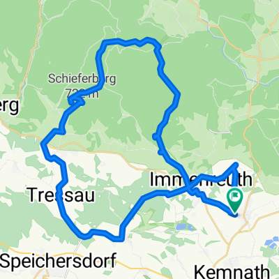
Ochsenkopfgipfel
A cycling route starting in Kulmain, Bavaria, Germany.
Overview
About this route
Kulmain-Döberein-Babylon-Frankenreuth nach Grünberg und auf den neuangelegten Fahradweg bis Fichtelberg,jetzt zum Fichtelsee hinauf von dort zur B303, links, nachca.200m wieder abbiegen zum kleinen Parkplatz,von da auf den Forstweg (untere Ringloipe) den Ochsenkopf fast umrunden,nun den Gipfelsturm in Angrif nehmen 1024mü.d.M. um nach einer verdienten Rast den Heimweg über Neubau-Fleckl-Königskron-Ahorberg und Immenreuth anzutreten.
Alle Wege gut befahrbar,Einkehrmöglichkeiten: Fichtelsee,Ochsenkopfgipfel,Ahornberg,
- -:--
- Duration
- 58.1 km
- Distance
- 819 m
- Ascent
- 819 m
- Descent
- ---
- Avg. speed
- ---
- Avg. speed

Continue with Bikemap
Use, edit, or download this cycling route
You would like to ride Ochsenkopfgipfel or customize it for your own trip? Here is what you can do with this Bikemap route:
Free features
- Save this route as favorite or in collections
- Copy & plan your own version of this route
- Sync your route with Garmin or Wahoo
Premium features
Free trial for 3 days, or one-time payment. More about Bikemap Premium.
- Navigate this route on iOS & Android
- Export a GPX / KML file of this route
- Create your custom printout (try it for free)
- Download this route for offline navigation
Discover more Premium features.
Get Bikemap PremiumFrom our community
Other popular routes starting in Kulmain
 Kulmain-Königskron-Schneeberg-Kulmain
- Distance
- 61.1 km
- Ascent
- 877 m
- Descent
- 877 m
- Location
- Kulmain, Bavaria, Germany
 Steinwaldtour
- Distance
- 61.7 km
- Ascent
- 737 m
- Descent
- 737 m
- Location
- Kulmain, Bavaria, Germany
 Ochsenkopfgipfel
- Distance
- 58.1 km
- Ascent
- 819 m
- Descent
- 819 m
- Location
- Kulmain, Bavaria, Germany
 Himmelsleiter-Ochsenkopf 16.08.11
- Distance
- 70.9 km
- Ascent
- 950 m
- Descent
- 950 m
- Location
- Kulmain, Bavaria, Germany
 Armesberg-Tour
- Distance
- 18.4 km
- Ascent
- 340 m
- Descent
- 340 m
- Location
- Kulmain, Bavaria, Germany
 Kulmain nach Waldhaus, rotwildgehege
- Distance
- 14.6 km
- Ascent
- 544 m
- Descent
- 202 m
- Location
- Kulmain, Bavaria, Germany
 Mountian bike, w/free ride thru woods
- Distance
- 19 km
- Ascent
- 365 m
- Descent
- 367 m
- Location
- Kulmain, Bavaria, Germany
 Der Berg ruft
- Distance
- 38.9 km
- Ascent
- 467 m
- Descent
- 467 m
- Location
- Kulmain, Bavaria, Germany
Open it in the app