

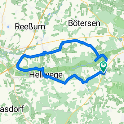
Eversen - Rotenburg - Hügelgräberroute
A cycling route starting in Ahausen, Lower Saxony, Germany.
Overview
About this route
Hügelgräberroute
- -:--
- Duration
- 47.5 km
- Distance
- 217 m
- Ascent
- 219 m
- Descent
- ---
- Avg. speed
- ---
- Avg. speed
Route quality
Waytypes & surfaces along the route
Waytypes
Quiet road
19 km
(40 %)
Track
11.6 km
(24 %)
Surfaces
Paved
22.4 km
(47 %)
Unpaved
9.2 km
(19 %)
Asphalt
16.2 km
(34 %)
Ground
5.7 km
(12 %)
Continue with Bikemap
Use, edit, or download this cycling route
You would like to ride Eversen - Rotenburg - Hügelgräberroute or customize it for your own trip? Here is what you can do with this Bikemap route:
Free features
- Save this route as favorite or in collections
- Copy & plan your own version of this route
- Sync your route with Garmin or Wahoo
Premium features
Free trial for 3 days, or one-time payment. More about Bikemap Premium.
- Navigate this route on iOS & Android
- Export a GPX / KML file of this route
- Create your custom printout (try it for free)
- Download this route for offline navigation
Discover more Premium features.
Get Bikemap PremiumFrom our community
Other popular routes starting in Ahausen
 3. Tour
- Distance
- 46.2 km
- Ascent
- 970 m
- Descent
- 933 m
- Location
- Ahausen, Lower Saxony, Germany
 Tag 1 Wümme Radweg
- Distance
- 34.3 km
- Ascent
- 86 m
- Descent
- 84 m
- Location
- Ahausen, Lower Saxony, Germany
 Ahausen - Daverden - Ahausen
- Distance
- 40.9 km
- Ascent
- 177 m
- Descent
- 177 m
- Location
- Ahausen, Lower Saxony, Germany
 Eversen - Fischerhude auf Wümmeradweg
- Distance
- 65.6 km
- Ascent
- 204 m
- Descent
- 204 m
- Location
- Ahausen, Lower Saxony, Germany
 RO-HH
RO-HH- Distance
- 85.2 km
- Ascent
- 219 m
- Descent
- 232 m
- Location
- Ahausen, Lower Saxony, Germany
 Unterstedt und umzu
- Distance
- 44.9 km
- Ascent
- 153 m
- Descent
- 153 m
- Location
- Ahausen, Lower Saxony, Germany
 hambourg2
- Distance
- 19.4 km
- Ascent
- 415 m
- Descent
- 413 m
- Location
- Ahausen, Lower Saxony, Germany
 Rund um die Ahauser Mühle.gpx
- Distance
- 4.3 km
- Ascent
- 29 m
- Descent
- 28 m
- Location
- Ahausen, Lower Saxony, Germany
Open it in the app