

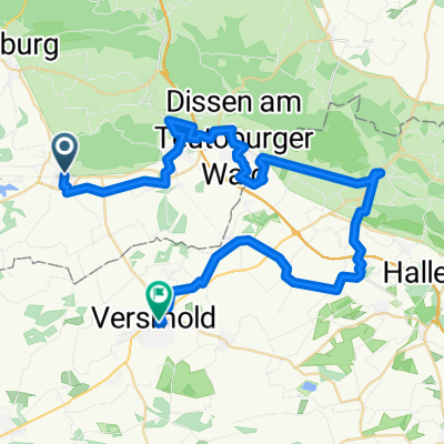
Rundtour Glandorf, Füchtorf -Cafepause Dinkelhof-
A cycling route starting in Bad Laer, Lower Saxony, Germany.
Overview
About this route
- 29,127,036,545 h 42 min
- Duration
- 34.7 km
- Distance
- 59 m
- Ascent
- 64 m
- Descent
- 0 km/h
- Avg. speed
- ---
- Avg. speed
Route quality
Waytypes & surfaces along the route
Waytypes
Quiet road
26.3 km
(76 %)
Track
3.7 km
(11 %)
Surfaces
Paved
28.8 km
(83 %)
Unpaved
2.7 km
(8 %)
Asphalt
24.9 km
(72 %)
Paved (undefined)
2.8 km
(8 %)
Continue with Bikemap
Use, edit, or download this cycling route
You would like to ride Rundtour Glandorf, Füchtorf -Cafepause Dinkelhof- or customize it for your own trip? Here is what you can do with this Bikemap route:
Free features
- Save this route as favorite or in collections
- Copy & plan your own version of this route
- Sync your route with Garmin or Wahoo
Premium features
Free trial for 3 days, or one-time payment. More about Bikemap Premium.
- Navigate this route on iOS & Android
- Export a GPX / KML file of this route
- Create your custom printout (try it for free)
- Download this route for offline navigation
Discover more Premium features.
Get Bikemap PremiumFrom our community
Other popular routes starting in Bad Laer
 Grenzgängertour 1.Tag
- Distance
- 46 km
- Ascent
- 105 m
- Descent
- 126 m
- Location
- Bad Laer, Lower Saxony, Germany
 Tag_fuer_Tag2
- Distance
- 31 km
- Ascent
- 186 m
- Descent
- 186 m
- Location
- Bad Laer, Lower Saxony, Germany
 Kleine Runde
- Distance
- 43.7 km
- Ascent
- 94 m
- Descent
- 94 m
- Location
- Bad Laer, Lower Saxony, Germany
 Dinkelhof - Füchtorf, Glandorf
- Distance
- 32.5 km
- Ascent
- 43 m
- Descent
- 43 m
- Location
- Bad Laer, Lower Saxony, Germany
 Rundtour Sassenberg mit einigen See`n
- Distance
- 29 km
- Ascent
- 55 m
- Descent
- 56 m
- Location
- Bad Laer, Lower Saxony, Germany
 Bad Laer-Vinnenberg -Bad Laer
- Distance
- 48.2 km
- Ascent
- 53 m
- Descent
- 56 m
- Location
- Bad Laer, Lower Saxony, Germany
 Rundtour von Bad Laer - Halle , mit einer Cafepause im Cafe Beuken Schmedt
- Distance
- 60.3 km
- Ascent
- 102 m
- Descent
- 100 m
- Location
- Bad Laer, Lower Saxony, Germany
 CE091122
- Distance
- 25.5 km
- Ascent
- 200 m
- Descent
- 200 m
- Location
- Bad Laer, Lower Saxony, Germany
Open it in the app