
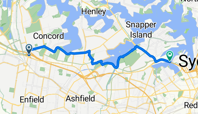
Alt. M4 to ANZAC Bridge
A cycling route starting in Homebush, New South Wales, Australia.
Overview
About this route
Alternative route from the beginning of the M4 to the ANZAC Bridge via Five Dock and Lilyfield. Longer but easier (and prettier) than the original (see http://www.bikemap.net/route/683128 for the original).
Avoids Gipps St/Queen St by taking Crane St/Lyons Rd instead. Usually quieter with fewer parked cars. The RTA has classified the road as "moderate difficulty on-road riding environment" but it's a pretty commonly used road by cyclists.
Avoids Lilyfield Rd by taking the scenic route along the Iron Cove Creek (also avoids the hill at Lilyfield Rd).
Once you reach Victoria Rd you have cycleways from there.
- -:--
- Duration
- 11.6 km
- Distance
- 115 m
- Ascent
- 144 m
- Descent
- ---
- Avg. speed
- ---
- Avg. speed
Continue with Bikemap
Use, edit, or download this cycling route
You would like to ride Alt. M4 to ANZAC Bridge or customize it for your own trip? Here is what you can do with this Bikemap route:
Free features
- Save this route as favorite or in collections
- Copy & plan your own version of this route
- Sync your route with Garmin or Wahoo
Premium features
Free trial for 3 days, or one-time payment. More about Bikemap Premium.
- Navigate this route on iOS & Android
- Export a GPX / KML file of this route
- Create your custom printout (try it for free)
- Download this route for offline navigation
Discover more Premium features.
Get Bikemap PremiumFrom our community
Other popular routes starting in Homebush
 Strathfield-Airport landing + take off
- Distance
- 18.1 km
- Ascent
- 66 m
- Descent
- 77 m
- Location
- Homebush, New South Wales, Australia
 Strathfield train station to Sydney Olympic Park - Route 2 , less trafic
- Distance
- 7.2 km
- Ascent
- 39 m
- Descent
- 55 m
- Location
- Homebush, New South Wales, Australia
 Parramatta Road 350, Homebush West to Parramatta
- Distance
- 9.1 km
- Ascent
- 72 m
- Descent
- 74 m
- Location
- Homebush, New South Wales, Australia
 Strathfield to City Farm via Prospect Reservoir
- Distance
- 50.5 km
- Ascent
- 189 m
- Descent
- 165 m
- Location
- Homebush, New South Wales, Australia
 39 Everton Rd, Strathfield to 12 Crane St, Canada Bay
- Distance
- 3.2 km
- Ascent
- 33 m
- Descent
- 45 m
- Location
- Homebush, New South Wales, Australia
 Strathfield railway station to Marceau Drive 33, Concord
- Distance
- 3.4 km
- Ascent
- 11 m
- Descent
- 29 m
- Location
- Homebush, New South Wales, Australia
 69 Redmyre Road, Strathfield to 2 Knox Street, Ashfield
- Distance
- 4.6 km
- Ascent
- 50 m
- Descent
- 50 m
- Location
- Homebush, New South Wales, Australia
 Around Wentworth Point
- Distance
- 25.5 km
- Ascent
- 159 m
- Descent
- 161 m
- Location
- Homebush, New South Wales, Australia
Open it in the app