

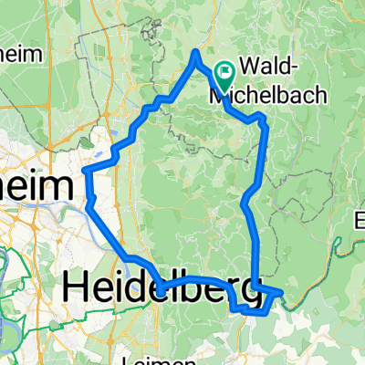
Siedelsbrunn -> BASF Tor 7 Ludwigshafen
A cycling route starting in Unter-Abtsteinach, Hesse, Germany.
Overview
About this route
Kürzester und schnellseter Weg mit dem Fahrrad
Am Anfang geht es nur bergab
Ab Weinheim ist es flach
- -:--
- Duration
- 32.4 km
- Distance
- 77 m
- Ascent
- 486 m
- Descent
- ---
- Avg. speed
- ---
- Avg. speed
Route quality
Waytypes & surfaces along the route
Waytypes
Busy road
14.3 km
(44 %)
Quiet road
8.5 km
(26 %)
Surfaces
Paved
32.2 km
(99 %)
Asphalt
31 km
(96 %)
Paving stones
1.1 km
(3 %)
Continue with Bikemap
Use, edit, or download this cycling route
You would like to ride Siedelsbrunn -> BASF Tor 7 Ludwigshafen or customize it for your own trip? Here is what you can do with this Bikemap route:
Free features
- Save this route as favorite or in collections
- Copy & plan your own version of this route
- Sync your route with Garmin or Wahoo
Premium features
Free trial for 3 days, or one-time payment. More about Bikemap Premium.
- Navigate this route on iOS & Android
- Export a GPX / KML file of this route
- Create your custom printout (try it for free)
- Download this route for offline navigation
Discover more Premium features.
Get Bikemap PremiumFrom our community
Other popular routes starting in Unter-Abtsteinach
 MTB-Marathon Siedelsbrunn
- Distance
- 50.8 km
- Ascent
- 953 m
- Descent
- 953 m
- Location
- Unter-Abtsteinach, Hesse, Germany
 Siedelsbrunn -> BASF Tor 7 Ludwigshafen
- Distance
- 32.4 km
- Ascent
- 77 m
- Descent
- 486 m
- Location
- Unter-Abtsteinach, Hesse, Germany
 Eiterbachtal
- Distance
- 80.2 km
- Ascent
- 495 m
- Descent
- 495 m
- Location
- Unter-Abtsteinach, Hesse, Germany
 Abtsteinach: Panoramaweg Abtsteinach – Aussichtsreiche Wanderrunde im Überwald
- Distance
- 16.2 km
- Ascent
- 483 m
- Descent
- 482 m
- Location
- Unter-Abtsteinach, Hesse, Germany
 Vö-Stillfüssel-Vö
- Distance
- 21.3 km
- Ascent
- 545 m
- Descent
- 546 m
- Location
- Unter-Abtsteinach, Hesse, Germany
 Oberflockenbach, Burg Windeck, Radwege
- Distance
- 12.5 km
- Ascent
- 292 m
- Descent
- 397 m
- Location
- Unter-Abtsteinach, Hesse, Germany
 Route nach Götzensteinstraße 60, Mörlenbach
- Distance
- 75.3 km
- Ascent
- 1,056 m
- Descent
- 1,069 m
- Location
- Unter-Abtsteinach, Hesse, Germany
 Heiligkreuzsteinach nach Weinheimer Straße, Wald-Michelbach
- Distance
- 24.5 km
- Ascent
- 1,421 m
- Descent
- 1,366 m
- Location
- Unter-Abtsteinach, Hesse, Germany
Open it in the app