

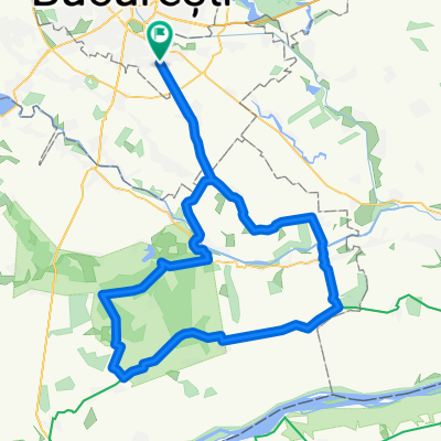
Bucuresti - Comana (via comuna Berceni)
A cycling route starting in Sector 4, București, Romania.
Overview
About this route
O ruta ce combina drumurile asfaltate cu cele de pietris. Atentie, dupa comuna Colibasi, trebuie sa treceti riul Arges pe un pod de beton armat.
- -:--
- Duration
- 72.4 km
- Distance
- 122 m
- Ascent
- 133 m
- Descent
- ---
- Avg. speed
- ---
- Avg. speed

Route highlights
Points of interest along the route
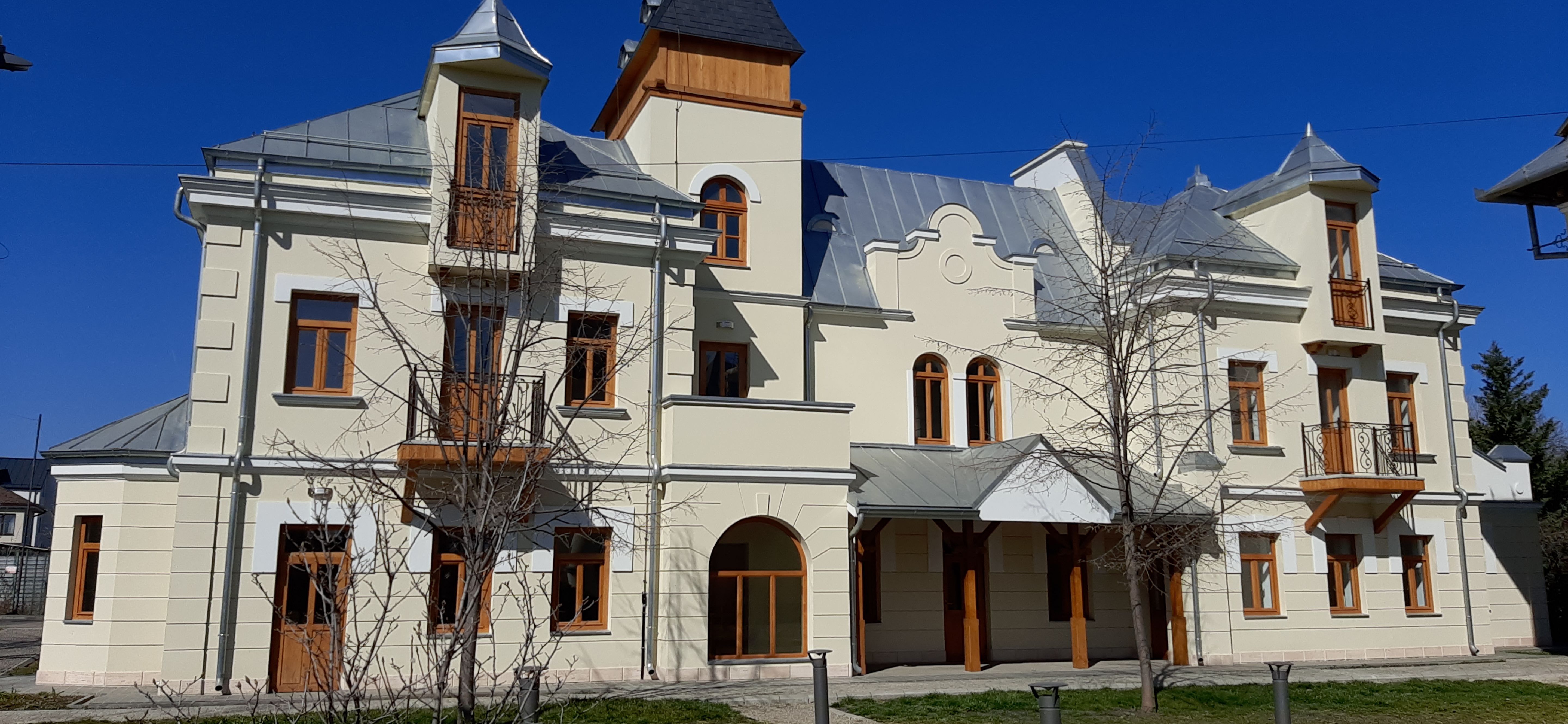
Point of interest after 35.1 km
Manastirea Comana
Continue with Bikemap
Use, edit, or download this cycling route
You would like to ride Bucuresti - Comana (via comuna Berceni) or customize it for your own trip? Here is what you can do with this Bikemap route:
Free features
- Save this route as favorite or in collections
- Copy & plan your own version of this route
- Sync your route with Garmin or Wahoo
Premium features
Free trial for 3 days, or one-time payment. More about Bikemap Premium.
- Navigate this route on iOS & Android
- Export a GPX / KML file of this route
- Create your custom printout (try it for free)
- Download this route for offline navigation
Discover more Premium features.
Get Bikemap PremiumFrom our community
Other popular routes starting in Sector 4
 Lengthy ride through Bucureşti
- Distance
- 82.1 km
- Ascent
- 145 m
- Descent
- 144 m
- Location
- Sector 4, București, Romania
 Bucuresti-Comana, on small county roads
- Distance
- 39.3 km
- Ascent
- 56 m
- Descent
- 85 m
- Location
- Sector 4, București, Romania
 Route from Strada Turnu Măgurele 44, București
- Distance
- 43.3 km
- Ascent
- 54 m
- Descent
- 121 m
- Location
- Sector 4, București, Romania
 Traseul Trenuletului
- Distance
- 1.5 km
- Ascent
- 4 m
- Descent
- 4 m
- Location
- Sector 4, București, Romania
 Dp2r: Gran Fondo Sud
- Distance
- 117.9 km
- Ascent
- 148 m
- Descent
- 152 m
- Location
- Sector 4, București, Romania
 Sud-Nord
- Distance
- 12.6 km
- Ascent
- 24 m
- Descent
- 65 m
- Location
- Sector 4, București, Romania
 Tură MTB Parcul Natural Văcărești
- Distance
- 5.7 km
- Ascent
- 13 m
- Descent
- 17 m
- Location
- Sector 4, București, Romania
 Route from Strada Izvorul Oltului
- Distance
- 137.1 km
- Ascent
- 358 m
- Descent
- 409 m
- Location
- Sector 4, București, Romania
Open it in the app