

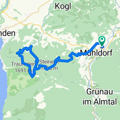
Viechtwang 33, Scharnstein nach Almsee 3, Grünau im Almtal
A cycling route starting in Scharnstein, Upper Austria, Austria.
Overview
About this route
- 1 h 18 min
- Duration
- 23.2 km
- Distance
- 300 m
- Ascent
- 230 m
- Descent
- 17.9 km/h
- Avg. speed
- ---
- Avg. speed

Route quality
Waytypes & surfaces along the route
Waytypes
Busy road
6.4 km
(27 %)
Quiet road
5.7 km
(24 %)
Surfaces
Paved
5.8 km
(25 %)
Unpaved
0.5 km
(2 %)
Asphalt
5.8 km
(25 %)
Gravel
0.5 km
(2 %)
Undefined
16.9 km
(73 %)
Continue with Bikemap
Use, edit, or download this cycling route
You would like to ride Viechtwang 33, Scharnstein nach Almsee 3, Grünau im Almtal or customize it for your own trip? Here is what you can do with this Bikemap route:
Free features
- Save this route as favorite or in collections
- Copy & plan your own version of this route
- Sync your route with Garmin or Wahoo
Premium features
Free trial for 3 days, or one-time payment. More about Bikemap Premium.
- Navigate this route on iOS & Android
- Export a GPX / KML file of this route
- Create your custom printout (try it for free)
- Download this route for offline navigation
Discover more Premium features.
Get Bikemap PremiumFrom our community
Other popular routes starting in Scharnstein
 von Scharnstein ins Almtal
- Distance
- 58.5 km
- Ascent
- 347 m
- Descent
- 353 m
- Location
- Scharnstein, Upper Austria, Austria
 laudachsee
- Distance
- 38.6 km
- Ascent
- 1,543 m
- Descent
- 1,544 m
- Location
- Scharnstein, Upper Austria, Austria
 2023_06_26_Steineck
- Distance
- 42.9 km
- Ascent
- 1,219 m
- Descent
- 1,220 m
- Location
- Scharnstein, Upper Austria, Austria
 2025_Viechtwang-Almsee
- Distance
- 59 km
- Ascent
- 1,039 m
- Descent
- 1,038 m
- Location
- Scharnstein, Upper Austria, Austria
 OBK Badeplatz Scharnstein Sensen und Flösserweg
- Distance
- 38.1 km
- Ascent
- 488 m
- Descent
- 482 m
- Location
- Scharnstein, Upper Austria, Austria
 2025_Viechtwang-Weyregg
- Distance
- 43.1 km
- Ascent
- 1,084 m
- Descent
- 1,107 m
- Location
- Scharnstein, Upper Austria, Austria
 OBK Schobermühle (Hendl) Scharnstein
- Distance
- 4.2 km
- Ascent
- 93 m
- Descent
- 25 m
- Location
- Scharnstein, Upper Austria, Austria
 Mühldorf nach Grünau im Altal
- Distance
- 20.7 km
- Ascent
- 266 m
- Descent
- 211 m
- Location
- Scharnstein, Upper Austria, Austria
Open it in the app