

Mozart Cycle Path – Stage 13: Kössen – Lofer
A cycling route starting in Kössen, Tyrol, Austria.
Overview
About this route
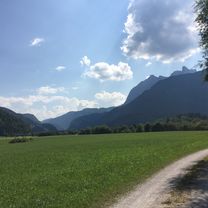
At an altitude of almost 600 metres, this is the most ‘mountainous’ stage of the entire Mozart cycle path. The appeal of this charming landscape of the Kohlen valley and later the Strub valley is therefore even greater for us. In the Achental valley, it is worth considering taking a detour to St. Johann in Tirol. The last part leads through the Strubtal valley, wildly romantic to Lofer and thus back into the Salzburger Land.
- -:--
- Duration
- 49.7 km
- Distance
- 681 m
- Ascent
- 640 m
- Descent
- ---
- Avg. speed
- ---
- Avg. speed

Route quality
Waytypes & surfaces along the route
Waytypes
Quiet road
13.2 km
(27 %)
Path
10.2 km
(21 %)
Surfaces
Paved
27.1 km
(55 %)
Unpaved
8.9 km
(18 %)
Asphalt
26.1 km
(52 %)
Gravel
8.7 km
(17 %)
Continue with Bikemap
Use, edit, or download this cycling route
You would like to ride Mozart Cycle Path – Stage 13: Kössen – Lofer or customize it for your own trip? Here is what you can do with this Bikemap route:
Free features
- Save this route as favorite or in collections
- Copy & plan your own version of this route
- Sync your route with Garmin or Wahoo
Premium features
Free trial for 3 days, or one-time payment. More about Bikemap Premium.
- Navigate this route on iOS & Android
- Export a GPX / KML file of this route
- Create your custom printout (try it for free)
- Download this route for offline navigation
Discover more Premium features.
Get Bikemap PremiumFrom our community
Other popular routes starting in Kössen
 Kössen, Weißbach , Walchsee, Kössen-Runde
- Distance
- 38.3 km
- Ascent
- 960 m
- Descent
- 962 m
- Location
- Kössen, Tyrol, Austria
 Rund um den Unterberg - Kössen
- Distance
- 57.2 km
- Ascent
- 605 m
- Descent
- 570 m
- Location
- Kössen, Tyrol, Austria
 Feldalm-Hochalm
- Distance
- 34.5 km
- Ascent
- 946 m
- Descent
- 946 m
- Location
- Kössen, Tyrol, Austria
 Bayr. Runde
- Distance
- 60.1 km
- Ascent
- 428 m
- Descent
- 428 m
- Location
- Kössen, Tyrol, Austria
 Erl - Aschau - Kössen
- Distance
- 80.4 km
- Ascent
- 456 m
- Descent
- 456 m
- Location
- Kössen, Tyrol, Austria
 Kössen - St. Johann Rundkurs
- Distance
- 43 km
- Ascent
- 771 m
- Descent
- 814 m
- Location
- Kössen, Tyrol, Austria
 Kössen - Bayrisch-Zell - Kufstein - Kössen
- Distance
- 103.7 km
- Ascent
- 2,079 m
- Descent
- 2,223 m
- Location
- Kössen, Tyrol, Austria
 Kössen - Kitzbühelhorn
- Distance
- 82.9 km
- Ascent
- 1,838 m
- Descent
- 1,958 m
- Location
- Kössen, Tyrol, Austria
Open it in the app