

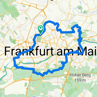
von der Nidda zur Hauptwache
A cycling route starting in Eschborn, Hesse, Germany.
Overview
About this route
kürzeste Strecke Am Opel Rondell am besten auf der linken Seite zwischen Ludwig - Landmann Strasse und Voltastrasse bleiben. Die Voltastrasse ist ziemlich schmal, da die Straßenbahnschienen auf einem erhöhten Gleisbett liege. Vorsicht!
- -:--
- Duration
- 5.3 km
- Distance
- 27 m
- Ascent
- 17 m
- Descent
- ---
- Avg. speed
- ---
- Avg. speed
Continue with Bikemap
Use, edit, or download this cycling route
You would like to ride von der Nidda zur Hauptwache or customize it for your own trip? Here is what you can do with this Bikemap route:
Free features
- Save this route as favorite or in collections
- Copy & plan your own version of this route
- Sync your route with Garmin or Wahoo
Premium features
Free trial for 3 days, or one-time payment. More about Bikemap Premium.
- Navigate this route on iOS & Android
- Export a GPX / KML file of this route
- Create your custom printout (try it for free)
- Download this route for offline navigation
Discover more Premium features.
Get Bikemap PremiumFrom our community
Other popular routes starting in Eschborn
 Feldberg MTB
- Distance
- 27.3 km
- Ascent
- 532 m
- Descent
- 42 m
- Location
- Eschborn, Hesse, Germany
 SKODA Velotour Frankfurt 2013 - 104km
- Distance
- 103.4 km
- Ascent
- 984 m
- Descent
- 984 m
- Location
- Eschborn, Hesse, Germany
 Vordertaunus mit leichtem Schneefall
- Distance
- 35.3 km
- Ascent
- 557 m
- Descent
- 557 m
- Location
- Eschborn, Hesse, Germany
 Grüngürtel
- Distance
- 62.4 km
- Ascent
- 278 m
- Descent
- 281 m
- Location
- Eschborn, Hesse, Germany
 Trainingsstrecke ŠKODA Velotour 104 km
- Distance
- 105.7 km
- Ascent
- 1,049 m
- Descent
- 1,047 m
- Location
- Eschborn, Hesse, Germany
 Grüngürtel
- Distance
- 62.5 km
- Ascent
- 202 m
- Descent
- 203 m
- Location
- Eschborn, Hesse, Germany
 CTF Hohemark
- Distance
- 46.9 km
- Ascent
- 658 m
- Descent
- 603 m
- Location
- Eschborn, Hesse, Germany
 F-Nied Main Rhein Wi-Äppelallee
- Distance
- 41.1 km
- Ascent
- 58 m
- Descent
- 63 m
- Location
- Eschborn, Hesse, Germany
Open it in the app