
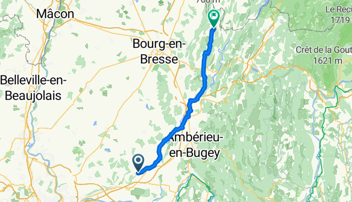
Itinéraire à partir de 16 Impasse du Mas Choquet, Bourg-Saint-Christophe
A cycling route starting in Béligneux, Auvergne-Rhône-Alpes, France.
Overview
About this route
- 5 h 11 min
- Duration
- 60.3 km
- Distance
- 734 m
- Ascent
- 660 m
- Descent
- 11.6 km/h
- Avg. speed
- ---
- Avg. speed
Route quality
Waytypes & surfaces along the route
Waytypes
Quiet road
31.4 km
(52 %)
Road
18.2 km
(30 %)
Surfaces
Paved
23.9 km
(40 %)
Asphalt
23.9 km
(40 %)
Undefined
36.4 km
(60 %)
Continue with Bikemap
Use, edit, or download this cycling route
You would like to ride Itinéraire à partir de 16 Impasse du Mas Choquet, Bourg-Saint-Christophe or customize it for your own trip? Here is what you can do with this Bikemap route:
Free features
- Save this route as favorite or in collections
- Copy & plan your own version of this route
- Sync your route with Garmin or Wahoo
Premium features
Free trial for 3 days, or one-time payment. More about Bikemap Premium.
- Navigate this route on iOS & Android
- Export a GPX / KML file of this route
- Create your custom printout (try it for free)
- Download this route for offline navigation
Discover more Premium features.
Get Bikemap PremiumFrom our community
Other popular routes starting in Béligneux
 De Chemin des Barmettes 54, Béligneux à Gare de la Valbonne, Béligneux
- Distance
- 1.2 km
- Ascent
- 16 m
- Descent
- 21 m
- Location
- Béligneux, Auvergne-Rhône-Alpes, France
 1628–1676 Montée de Béligneux, Béligneux à Le Clos Eugénie, Dagneux
- Distance
- 22.2 km
- Ascent
- 154 m
- Descent
- 197 m
- Location
- Béligneux, Auvergne-Rhône-Alpes, France
 vtt pluvieux
- Distance
- 18 km
- Ascent
- 178 m
- Descent
- 177 m
- Location
- Béligneux, Auvergne-Rhône-Alpes, France
 Facile à conduire Béligneux
- Distance
- 34.7 km
- Ascent
- 456 m
- Descent
- 457 m
- Location
- Béligneux, Auvergne-Rhône-Alpes, France
 journée 1 jusque Saint Prim
- Distance
- 87.9 km
- Ascent
- 1,458 m
- Descent
- 1,485 m
- Location
- Béligneux, Auvergne-Rhône-Alpes, France
 Béligneux à Chemin du Grand Brotteau, Neyron
- Distance
- 23.6 km
- Ascent
- 92 m
- Descent
- 115 m
- Location
- Béligneux, Auvergne-Rhône-Alpes, France
 Itinéraire modéré en Pizay
- Distance
- 0.9 km
- Ascent
- 9 m
- Descent
- 0 m
- Location
- Béligneux, Auvergne-Rhône-Alpes, France
 Monteillier / Vougy
- Distance
- 28.4 km
- Ascent
- 66 m
- Descent
- 176 m
- Location
- Béligneux, Auvergne-Rhône-Alpes, France
Open it in the app