
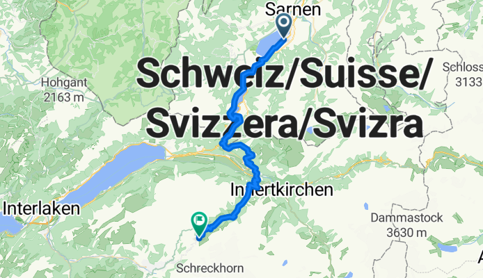
Sachseln - Brünig - große Scheidegg - and back
A cycling route starting in Sachseln, Canton of Obwalden, Switzerland.
Overview
About this route
Start in Sachseln, über die sehr steile Panorama-Straße nach Lungern, von hier weiter über den Brünig-Radweg nach Meiringen und hoch auf die große Scheidegg. In diesem Fall den gleichen Weg zurück, natürlich ginge auch eine Runde um den Brienzer See. Doch das ein anderes Mal...
- -:--
- Duration
- 46.2 km
- Distance
- 2,033 m
- Ascent
- 556 m
- Descent
- ---
- Avg. speed
- ---
- Avg. speed

Continue with Bikemap
Use, edit, or download this cycling route
You would like to ride Sachseln - Brünig - große Scheidegg - and back or customize it for your own trip? Here is what you can do with this Bikemap route:
Free features
- Save this route as favorite or in collections
- Copy & plan your own version of this route
- Sync your route with Garmin or Wahoo
Premium features
Free trial for 3 days, or one-time payment. More about Bikemap Premium.
- Navigate this route on iOS & Android
- Export a GPX / KML file of this route
- Create your custom printout (try it for free)
- Download this route for offline navigation
Discover more Premium features.
Get Bikemap PremiumFrom our community
Other popular routes starting in Sachseln
 Sachseln - Glaubenberg - Entlebuch - Sörenberg - Glaubenbielen - Sachseln
- Distance
- 85.9 km
- Ascent
- 2,035 m
- Descent
- 2,032 m
- Location
- Sachseln, Canton of Obwalden, Switzerland
 07 Sachseln - Hochdorf
- Distance
- 48.8 km
- Ascent
- 352 m
- Descent
- 361 m
- Location
- Sachseln, Canton of Obwalden, Switzerland
 Melchsee-Planplatten-Tour
- Distance
- 62 km
- Ascent
- 2,057 m
- Descent
- 2,058 m
- Location
- Sachseln, Canton of Obwalden, Switzerland
 los Glaunberg
- Distance
- 82.7 km
- Ascent
- 1,985 m
- Descent
- 1,986 m
- Location
- Sachseln, Canton of Obwalden, Switzerland
 CH19_Rund um den Sarner See (gU)
- Distance
- 17.3 km
- Ascent
- 133 m
- Descent
- 133 m
- Location
- Sachseln, Canton of Obwalden, Switzerland
 V2_E04_ALPX_Schweiz
- Distance
- 45.5 km
- Ascent
- 2,673 m
- Descent
- 1,203 m
- Location
- Sachseln, Canton of Obwalden, Switzerland
 14-C07-Sempach
- Distance
- 48.3 km
- Ascent
- 323 m
- Descent
- 298 m
- Location
- Sachseln, Canton of Obwalden, Switzerland
 CHALLENGE_07
- Distance
- 49.7 km
- Ascent
- 314 m
- Descent
- 290 m
- Location
- Sachseln, Canton of Obwalden, Switzerland
Open it in the app