

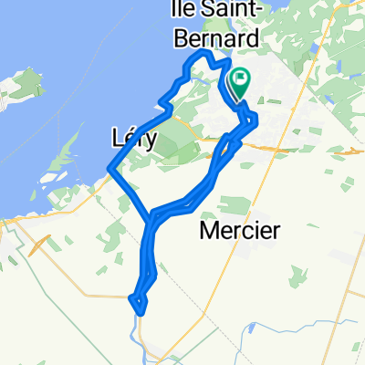
Châteauguay - Beauharnois - Ste-Martine loop
A cycling route starting in Châteauguay, Quebec, Canada.
Overview
About this route
Léry waterfront is beautiful with public beach (no swimming). Route Verte #3 along Parc Regional Beauharnois-Salaberry paved rail trail. Parking available at start near bike path behind Municipal Library.
- -:--
- Duration
- 44.7 km
- Distance
- 43 m
- Ascent
- 43 m
- Descent
- ---
- Avg. speed
- 40 m
- Avg. speed

Route quality
Waytypes & surfaces along the route
Waytypes
Road
16.5 km
(37 %)
Quiet road
14 km
(31 %)
Surfaces
Paved
36.4 km
(81 %)
Unpaved
0.1 km
(<1 %)
Asphalt
32.5 km
(73 %)
Paved (undefined)
3.9 km
(9 %)
Continue with Bikemap
Use, edit, or download this cycling route
You would like to ride Châteauguay - Beauharnois - Ste-Martine loop or customize it for your own trip? Here is what you can do with this Bikemap route:
Free features
- Save this route as favorite or in collections
- Copy & plan your own version of this route
- Sync your route with Garmin or Wahoo
Premium features
Free trial for 3 days, or one-time payment. More about Bikemap Premium.
- Navigate this route on iOS & Android
- Export a GPX / KML file of this route
- Create your custom printout (try it for free)
- Download this route for offline navigation
Discover more Premium features.
Get Bikemap PremiumFrom our community
Other popular routes starting in Châteauguay
 Boucle lac st-louis-beauharnois-ste-martine 3 septembre 08:28
- Distance
- 41.3 km
- Ascent
- 35 m
- Descent
- 23 m
- Location
- Châteauguay, Quebec, Canada
 Chateaugay-St-Louis de Gonzague-Beauharnois
- Distance
- 75.7 km
- Ascent
- 51 m
- Descent
- 51 m
- Location
- Châteauguay, Quebec, Canada
 Chautauguay(Circuit de la rivière Châtauguay)
- Distance
- 56.3 km
- Ascent
- 79 m
- Descent
- 76 m
- Location
- Châteauguay, Quebec, Canada
 Itinéraire vers 500 Boul d'Youville, Châteauguay
- Distance
- 41.7 km
- Ascent
- 83 m
- Descent
- 88 m
- Location
- Châteauguay, Quebec, Canada
 186 Rue de Liège, Châteauguay to 184 Rue de Liège, Châteauguay
- Distance
- 42 km
- Ascent
- 106 m
- Descent
- 104 m
- Location
- Châteauguay, Quebec, Canada
 Boulevard D'Youville 5, Châteauguay to Rue des Sittelles 200, Châteauguay
- Distance
- 38.7 km
- Ascent
- 170 m
- Descent
- 172 m
- Location
- Châteauguay, Quebec, Canada
 Chateauguay 35 km
- Distance
- 34.5 km
- Ascent
- 34 m
- Descent
- 35 m
- Location
- Châteauguay, Quebec, Canada
 Chateauguay-Ormstown 109km
- Distance
- 109.9 km
- Ascent
- 49 m
- Descent
- 47 m
- Location
- Châteauguay, Quebec, Canada
Open it in the app