

Ride report - Lake Como
A cycling route starting in Porlezza, Lombardy, Italy.
Overview
About this route
<span style="color: #3e3e3e; font-family: Verdana, Geneva, sans-serif; font-size: 11px; line-height: 17px;"> </span>
<span style="color: #3e3e3e; font-family: Verdana, Geneva, sans-serif; line-height: 17px;">
I was accompanied by my good friends Mike Ho and Jan Skovgaard for the various rides we had planned over the next three days. Based out of Andermatt, Switzerland we were close to some spectacular riding spots, all with in a short drive from our base. In order get ourselves prepared for day 2 which was to include 3,000 m+ climbing over 3 passes, we elected to do a relatively flat ride around Lake Como on day 1.
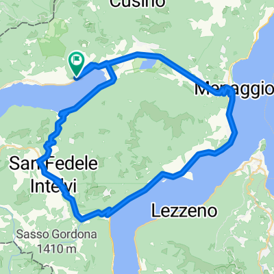
Day 1
Lake Como is a lake of glacial origin in Lombardy, Italy. It has an area of 146 km², making it the third largest lake in Italy, after Lake Garda and Lake Maggiore.
The drive from Andermatt, Switzerland to Porlezza on the eastern tip of Lake Como took around an hour and a half with the weather improving as we headed south down the E35. Over the years, I had followed via TV/ Internet the Giro di Lombardia race held in the area each September, I was therefore really looking forward to actually riding some of the twisting narrow roads that this area is famous for.
The ride that we had planned would consist of a gentle climb from Porlezza to the top of the hill overlooking Lake Como, which then dropped quickly to the edge of the lake via a fast and technical descent to Menaggio. The ride from Menaggio to Como was around 30 km at an average speed of a comfortable 30 km/h. Despite it being a weekday there were many cyclists along the road in both directions and we were greeted by some beautiful towns along the way, such as Mezzagra, Lenno and Ossuccio.
As the road twisted in and out along the contours of the Lake we were able to see Como in the distance and looked forward to our first rest stop on the waterfront of Como. After a brief stop and some Italian appetizers we headed east to find the road to Bellagio but got completely mislead by the confusing road signs in and around Como. Without a map at hand, we mistakenly followed the signs for the main road that heads west, up and over the hill to Bellagio, instead of our preferred course along the shores of Lake Como. We had climbed 210 m over 6 km before deciding to turn around and back to Como.
Heading back into Como we quickly spotted the “other” signs for Bellagio, which directed us to the undulating road that hugged the contours to the eastern side of the lake. The road to Bellagio was very different from the road from Mennagio to Como, which was relatively flat and close to the water’s edge. In comparison, the eastern side of the lake was much steeper and more undulating than before. The scenery was no less spectacular as traditional and contemporary houses clung to the side of the hill.
By the time we reached Bellagio, many of the tourists in the area were finishing their lunch and we were therefore able to find a good spot for a well-earned late lunch. The view across the lake to Mennagio from where we had earlier started our ride along the lake was well worth the effort despite the extortionate cost of the lunch. We were in tourism grand central after all.
After lunch we headed to the ferry pier to wait for the next ferry across the lake to Griante. The ferry took approximately 15 minutes and from there we rode tempo back to Mennagio to begin our climb up and over to Porlezza. Having refueled after our ride to Bellagio we were keen to end the ride on a fast note, and rode briskly up from Mennagio, navigating the narrow and busy hairpins that traversed the side of the hill.
Before heading back to Andermatt we stopped in Lugano, Switzerland for a quick visit to the newly opened Assos concept store where the world’s first carbon fiber bike was on display along side their collection of luxurious cyclewear. After getting a personal tour of the store and coming away with some Assos freebies (mugs & chocolate) we were ready for some carbo-loading in downtown Lugano.
In total, the ride covered 105 km with 1,140 m (including portion of the ride where we were lost near Como) taking in some stunning scenery and served as a good training session for tomorrow, when we will take on the far more challenging Swiss Alps.
</span>
- -:--
- Duration
- 104 km
- Distance
- 838 m
- Ascent
- 839 m
- Descent
- ---
- Avg. speed
- ---
- Avg. speed

Continue with Bikemap
Use, edit, or download this cycling route
You would like to ride Ride report - Lake Como or customize it for your own trip? Here is what you can do with this Bikemap route:
Free features
- Save this route as favorite or in collections
- Copy & plan your own version of this route
- Sync your route with Garmin or Wahoo
Premium features
Free trial for 3 days, or one-time payment. More about Bikemap Premium.
- Navigate this route on iOS & Android
- Export a GPX / KML file of this route
- Create your custom printout (try it for free)
- Download this route for offline navigation
Discover more Premium features.
Get Bikemap PremiumFrom our community
Other popular routes starting in Porlezza
 Lasse 1
- Distance
- 52.7 km
- Ascent
- 759 m
- Descent
- 757 m
- Location
- Porlezza, Lombardy, Italy
 Lange Radrunde durch Porlezza
- Distance
- 44.2 km
- Ascent
- 1,217 m
- Descent
- 1,219 m
- Location
- Porlezza, Lombardy, Italy
 3. nap Porlezza to Como
- Distance
- 52.8 km
- Ascent
- 966 m
- Descent
- 1,052 m
- Location
- Porlezza, Lombardy, Italy
 Route Porlezza - Lago Maggiore
- Distance
- 127.9 km
- Ascent
- 2,276 m
- Descent
- 2,276 m
- Location
- Porlezza, Lombardy, Italy
 Porlezza- Alpe di Leno
- Distance
- 15.1 km
- Ascent
- 1,344 m
- Descent
- 138 m
- Location
- Porlezza, Lombardy, Italy
 StartPorlezza 002
- Distance
- 99.5 km
- Ascent
- 2,071 m
- Descent
- 2,074 m
- Location
- Porlezza, Lombardy, Italy
 Val Mara-Sighignola-Tremezzina-Val Cavargna
- Distance
- 134.1 km
- Ascent
- 2,484 m
- Descent
- 2,484 m
- Location
- Porlezza, Lombardy, Italy
 Splügen pass negyedik nap
- Distance
- 64.2 km
- Ascent
- 1,246 m
- Descent
- 1,243 m
- Location
- Porlezza, Lombardy, Italy
Open it in the app