

Nadbużański Szlak Rowerowy na Mazowszu
A cycling route starting in Tłuszcz, Masovian Voivodeship, Poland.
Overview
About this route
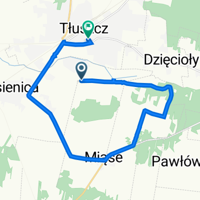
Start w Tłuszczu, od Wyszkowa Nadbużańskim Szlakiem Rowerowym do końca województwa mazowieckiego i koniec w Siedlcach.
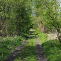
Ciekawa wycieczka rowerowa, częściowo po asfaltowych a częściowo po leśnych i polnych ścieżkach.
Dłuższy opis tu: https://majatravels.com/pl/nadbuzanski-szlak-rowerowy-czesc-mazowiecka/
- -:--
- Duration
- 170.9 km
- Distance
- 697 m
- Ascent
- 648 m
- Descent
- ---
- Avg. speed
- ---
- Avg. speed

Route photos


Route quality
Waytypes & surfaces along the route
Waytypes
Road
74.5 km
(44 %)
Quiet road
57.1 km
(33 %)
Surfaces
Paved
99.2 km
(58 %)
Unpaved
23.7 km
(14 %)
Asphalt
91.4 km
(53 %)
Unpaved (undefined)
13.5 km
(8 %)
Continue with Bikemap
Use, edit, or download this cycling route
You would like to ride Nadbużański Szlak Rowerowy na Mazowszu or customize it for your own trip? Here is what you can do with this Bikemap route:
Free features
- Save this route as favorite or in collections
- Copy & plan your own version of this route
- Sync your route with Garmin or Wahoo
Premium features
Free trial for 3 days, or one-time payment. More about Bikemap Premium.
- Navigate this route on iOS & Android
- Export a GPX / KML file of this route
- Create your custom printout (try it for free)
- Download this route for offline navigation
Discover more Premium features.
Get Bikemap PremiumFrom our community
Other popular routes starting in Tłuszcz
 Tłuszcz -> Jadów -> Wołomin -> Bródno -> Bielany
- Distance
- 79.3 km
- Ascent
- 108 m
- Descent
- 110 m
- Location
- Tłuszcz, Masovian Voivodeship, Poland
 Na zamek Liw
- Distance
- 140.3 km
- Ascent
- 200 m
- Descent
- 198 m
- Location
- Tłuszcz, Masovian Voivodeship, Poland
 yhymh
yhymh- Distance
- 61.9 km
- Ascent
- 1,117 m
- Descent
- 1,118 m
- Location
- Tłuszcz, Masovian Voivodeship, Poland
 Nadbużański Szlak Rowerowy na Mazowszu
- Distance
- 170.9 km
- Ascent
- 697 m
- Descent
- 648 m
- Location
- Tłuszcz, Masovian Voivodeship, Poland
 Tluszcz - Jeruzal - Gora Kalwaria 132km
- Distance
- 132.3 km
- Ascent
- 193 m
- Descent
- 204 m
- Location
- Tłuszcz, Masovian Voivodeship, Poland
 Mała szosowa ósemka wschód Warszawy
- Distance
- 51.5 km
- Ascent
- 73 m
- Descent
- 74 m
- Location
- Tłuszcz, Masovian Voivodeship, Poland
 Parkowa 53H, Miąse do T Kościuszki 18, Tłuszcz
- Distance
- 12.4 km
- Ascent
- 43 m
- Descent
- 40 m
- Location
- Tłuszcz, Masovian Voivodeship, Poland
 Ryki 2016
- Distance
- 241.9 km
- Ascent
- 260 m
- Descent
- 244 m
- Location
- Tłuszcz, Masovian Voivodeship, Poland
Open it in the app