

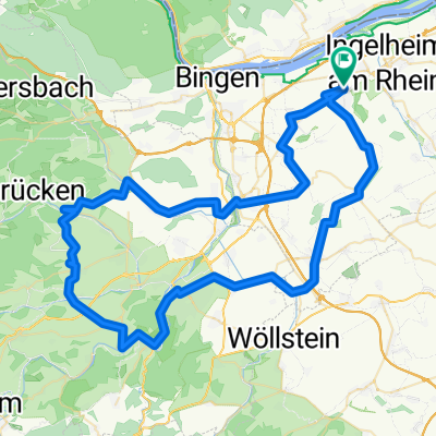
006f Ingelheim - Ober Hilbersheim - Wörrstadt - Wallertheim -Stadecken Elsheim -Ingelheim
A cycling route starting in Gau-Algesheim, Rhineland-Palatinate, Germany.
Overview
About this route
Ingelheim - Gau Algesheim - Appenheim - Nieder Hilbersheim - Ober Hilbersheim - Sender - Wörrstadt - Rommersheim - Schimsheim - Wallertheim - Gau Weinheim - Wolfsheim - Partenheim - Jugenheim - Stadecken Elsheim - Schwabenheim - Großwinternheim - Ingelheim
- -:--
- Duration
- 52.7 km
- Distance
- 397 m
- Ascent
- 398 m
- Descent
- ---
- Avg. speed
- 259 m
- Avg. speed
Route quality
Waytypes & surfaces along the route
Waytypes
Busy road
32 km
(61 %)
Road
7 km
(13 %)
Surfaces
Paved
49.9 km
(95 %)
Unpaved
1.4 km
(3 %)
Asphalt
48.9 km
(93 %)
Ground
0.7 km
(1 %)
Continue with Bikemap
Use, edit, or download this cycling route
You would like to ride 006f Ingelheim - Ober Hilbersheim - Wörrstadt - Wallertheim -Stadecken Elsheim -Ingelheim or customize it for your own trip? Here is what you can do with this Bikemap route:
Free features
- Save this route as favorite or in collections
- Copy & plan your own version of this route
- Sync your route with Garmin or Wahoo
Premium features
Free trial for 3 days, or one-time payment. More about Bikemap Premium.
- Navigate this route on iOS & Android
- Export a GPX / KML file of this route
- Create your custom printout (try it for free)
- Download this route for offline navigation
Discover more Premium features.
Get Bikemap PremiumFrom our community
Other popular routes starting in Gau-Algesheim
 006e Klassiker plus²
- Distance
- 53.3 km
- Ascent
- 352 m
- Descent
- 350 m
- Location
- Gau-Algesheim, Rhineland-Palatinate, Germany
 012 Ingelheim - Donnersberg - Ingelheim
- Distance
- 115.6 km
- Ascent
- 1,452 m
- Descent
- 1,378 m
- Location
- Gau-Algesheim, Rhineland-Palatinate, Germany
 016a Ingelheim - Schöneberg - Seibersbach - Stromberg - Roth - Ingelheim
- Distance
- 70.3 km
- Ascent
- 801 m
- Descent
- 799 m
- Location
- Gau-Algesheim, Rhineland-Palatinate, Germany
 016b Ingelheim - Hergenfeld - Schöneberg - Stromberg - Roth - Ingelheim
- Distance
- 66.4 km
- Ascent
- 795 m
- Descent
- 790 m
- Location
- Gau-Algesheim, Rhineland-Palatinate, Germany
 001a Ingelheim - Rümmelsheim - Daxweiler - Ingelheim
- Distance
- 67.2 km
- Ascent
- 784 m
- Descent
- 778 m
- Location
- Gau-Algesheim, Rhineland-Palatinate, Germany
 Tour de Hügel No.1
- Distance
- 80.6 km
- Ascent
- 667 m
- Descent
- 670 m
- Location
- Gau-Algesheim, Rhineland-Palatinate, Germany
 011c Ingelheim - Pfaffen-Schwabenheim - Vendersheim - Ingelheim
- Distance
- 57.5 km
- Ascent
- 529 m
- Descent
- 511 m
- Location
- Gau-Algesheim, Rhineland-Palatinate, Germany
 009c Ingelheim - Daxweiler - Stromberg - Horrweiler - Ingelheim
- Distance
- 66.1 km
- Ascent
- 659 m
- Descent
- 643 m
- Location
- Gau-Algesheim, Rhineland-Palatinate, Germany
Open it in the app