

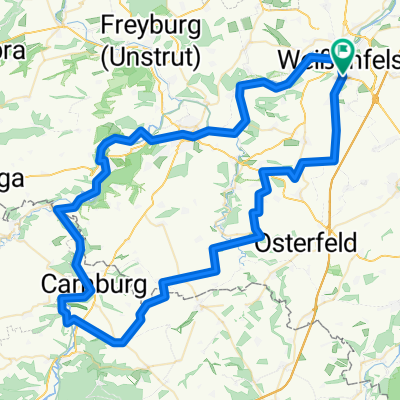
Walter-Schade-Straße 14, Weißenfels nach Zeitzer Straße 45, Weißenfels
A cycling route starting in Weißenfels, Saxony-Anhalt, Germany.
Overview
About this route
- 2 h 9 min
- Duration
- 45 km
- Distance
- 347 m
- Ascent
- 342 m
- Descent
- 20.9 km/h
- Avg. speed
- ---
- Avg. speed

Route quality
Waytypes & surfaces along the route
Waytypes
Quiet road
20.5 km
(45 %)
Track
7.2 km
(16 %)
Surfaces
Paved
36.2 km
(80 %)
Unpaved
3.6 km
(8 %)
Asphalt
33.6 km
(75 %)
Gravel
2.3 km
(5 %)
Continue with Bikemap
Use, edit, or download this cycling route
You would like to ride Walter-Schade-Straße 14, Weißenfels nach Zeitzer Straße 45, Weißenfels or customize it for your own trip? Here is what you can do with this Bikemap route:
Free features
- Save this route as favorite or in collections
- Copy & plan your own version of this route
- Sync your route with Garmin or Wahoo
Premium features
Free trial for 3 days, or one-time payment. More about Bikemap Premium.
- Navigate this route on iOS & Android
- Export a GPX / KML file of this route
- Create your custom printout (try it for free)
- Download this route for offline navigation
Discover more Premium features.
Get Bikemap PremiumFrom our community
Other popular routes starting in Weißenfels
 Runde2025
- Distance
- 487.1 km
- Ascent
- 3,574 m
- Descent
- 3,573 m
- Location
- Weißenfels, Saxony-Anhalt, Germany
 Zeitzer Gärten, Weißenfels nach Karl-Marx-Siedlung 49, Weißenfels
- Distance
- 8.5 km
- Ascent
- 84 m
- Descent
- 87 m
- Location
- Weißenfels, Saxony-Anhalt, Germany
 WSF 001: Weißenfelsrunde 1
- Distance
- 85.5 km
- Ascent
- 436 m
- Descent
- 436 m
- Location
- Weißenfels, Saxony-Anhalt, Germany
 WSF 002: Weißenfelsrunde 2
- Distance
- 93.3 km
- Ascent
- 347 m
- Descent
- 347 m
- Location
- Weißenfels, Saxony-Anhalt, Germany
 SRW_Etappe7
- Distance
- 68.8 km
- Ascent
- 135 m
- Descent
- 143 m
- Location
- Weißenfels, Saxony-Anhalt, Germany
 Weißensfels - Bad Kösen
- Distance
- 30.8 km
- Ascent
- 119 m
- Descent
- 102 m
- Location
- Weißenfels, Saxony-Anhalt, Germany
 12 Apostelbrücke
- Distance
- 119.4 km
- Ascent
- 360 m
- Descent
- 360 m
- Location
- Weißenfels, Saxony-Anhalt, Germany
 Südfeldsee und Saaleradweg
- Distance
- 28.9 km
- Ascent
- 167 m
- Descent
- 165 m
- Location
- Weißenfels, Saxony-Anhalt, Germany
Open it in the app