
valquirico
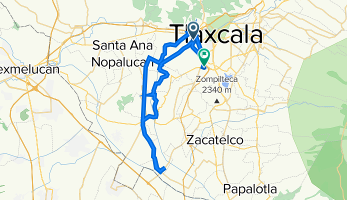
A cycling route starting in Zaragoza, Tlaxcala, Mexico.
Overview
About this route
- 5 h 18 min
- Duration
- 55.3 km
- Distance
- 681 m
- Ascent
- 615 m
- Descent
- 10.4 km/h
- Avg. speed
- ---
- Avg. speed

Continue with Bikemap
Use, edit, or download this cycling route
You would like to ride valquirico or customize it for your own trip? Here is what you can do with this Bikemap route:
Free features
- Save this route as favorite or in collections
- Copy & plan your own version of this route
- Sync your route with Garmin or Wahoo
Premium features
Free trial for 3 days, or one-time payment. More about Bikemap Premium.
- Navigate this route on iOS & Android
- Export a GPX / KML file of this route
- Create your custom printout (try it for free)
- Download this route for offline navigation
Discover more Premium features.
Get Bikemap PremiumFrom our community
Other popular routes starting in Zaragoza
 nocturna 26 junio
- Distance
- 13.2 km
- Ascent
- 139 m
- Descent
- 141 m
- Location
- Zaragoza, Tlaxcala, Mexico
 De Avenida Zahuapan 136, Panotla a Calle Circuito Perimetral Poniente, San Miguel del Milagro
- Distance
- 16.6 km
- Ascent
- 207 m
- Descent
- 113 m
- Location
- Zaragoza, Tlaxcala, Mexico
 De Carretera Federal San Martin-Tlaxcala 28, San Juan Totolac a Carretera Federal San Martin-Tlaxcala 28, San Juan Totolac
- Distance
- 8 km
- Ascent
- 1,137 m
- Descent
- 506 m
- Location
- Zaragoza, Tlaxcala, Mexico
 De Avenida Zahuapan 136, Panotla a Avenida Zahuapan 136, Panotla
- Distance
- 35.6 km
- Ascent
- 380 m
- Descent
- 385 m
- Location
- Zaragoza, Tlaxcala, Mexico
 De Avenida Zahuapan 136, Panotla a Camino Real a San Martin 23, Totolac
- Distance
- 37.5 km
- Ascent
- 490 m
- Descent
- 492 m
- Location
- Zaragoza, Tlaxcala, Mexico
 De Avenida Zahuapan 2, Panotla a Avenida Zahuapan 2, Panotla
- Distance
- 8.6 km
- Ascent
- 86 m
- Descent
- 90 m
- Location
- Zaragoza, Tlaxcala, Mexico
 De Universidad AREA VERDE, Tlaxcala de Xicohténcatl a Avenida Juárez 9, Tlaxcala de Xicohténcatl
- Distance
- 3.4 km
- Ascent
- 97 m
- Descent
- 102 m
- Location
- Zaragoza, Tlaxcala, Mexico
 De Avenida Independencia 60, Tlaxcala de Xicohténcatl a Del Jardín 32a, Tlaxcala de Xicohténcatl
- Distance
- 33.7 km
- Ascent
- 1,034 m
- Descent
- 1,050 m
- Location
- Zaragoza, Tlaxcala, Mexico
Open it in the app