

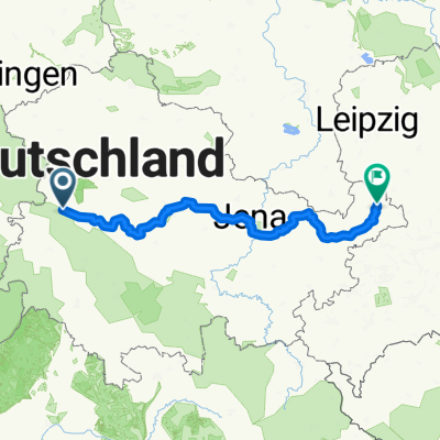
1 Eisenach Gotha
A cycling route starting in Eisenach, Free State of Thuringia, Germany.
Overview
About this route
Route von „Bahnhofstraße, 99817 Eisenach“ nach „Schützenberg 17, 99867 Gotha“ via „L3007, 99820 Hörselberg-Hainich“, „99880 Hörsel, 99880 Hörsel“, „Am Bahnhof, 99880 Hörsel“, „99880 Waltershausen, 99880 Waltershausen“, „Schützenberg 6, 99867 Gotha“, „Kleingartenweg, 99867 Gotha“, „Friedrich-Ebert-Straße 3, 99867 Gotha“
- 3 h 11 min
- Duration
- 44.5 km
- Distance
- 249 m
- Ascent
- 167 m
- Descent
- 14 km/h
- Avg. speed
- ---
- Avg. speed
Route quality
Waytypes & surfaces along the route
Waytypes
Quiet road
16.1 km
(36 %)
Track
8.3 km
(19 %)
Surfaces
Paved
26.1 km
(59 %)
Unpaved
5.6 km
(13 %)
Asphalt
25.4 km
(57 %)
Gravel
5 km
(11 %)
Continue with Bikemap
Use, edit, or download this cycling route
You would like to ride 1 Eisenach Gotha or customize it for your own trip? Here is what you can do with this Bikemap route:
Free features
- Save this route as favorite or in collections
- Copy & plan your own version of this route
- Sync your route with Garmin or Wahoo
Premium features
Free trial for 3 days, or one-time payment. More about Bikemap Premium.
- Navigate this route on iOS & Android
- Export a GPX / KML file of this route
- Create your custom printout (try it for free)
- Download this route for offline navigation
Discover more Premium features.
Get Bikemap PremiumFrom our community
Other popular routes starting in Eisenach
 Trailschaukel Eisenach
- Distance
- 35.8 km
- Ascent
- 923 m
- Descent
- 923 m
- Location
- Eisenach, Free State of Thuringia, Germany
 Goethestraße, Eisenach nach Planstraße, Amt Creuzburg
- Distance
- 26.1 km
- Ascent
- 394 m
- Descent
- 431 m
- Location
- Eisenach, Free State of Thuringia, Germany
 Zentraler Thüringer Wald
- Distance
- 99.9 km
- Ascent
- 1,260 m
- Descent
- 1,260 m
- Location
- Eisenach, Free State of Thuringia, Germany
 Eisenach-Gotha
- Distance
- 43.2 km
- Ascent
- 272 m
- Descent
- 190 m
- Location
- Eisenach, Free State of Thuringia, Germany
 07.Wer.Eisen.-Philipst.
- Distance
- 195.8 km
- Ascent
- 2,079 m
- Descent
- 1,479 m
- Location
- Eisenach, Free State of Thuringia, Germany
 Thüringer Radfernwege - 11 - Thüringer Städtekette - D-Route 4
- Distance
- 233.6 km
- Ascent
- 1,500 m
- Descent
- 1,543 m
- Location
- Eisenach, Free State of Thuringia, Germany
 Wilhelm-Pieck-Straße 18, Eisenach nach Wilhelm-Pieck-Straße 16, Eisenach
- Distance
- 15.7 km
- Ascent
- 228 m
- Descent
- 222 m
- Location
- Eisenach, Free State of Thuringia, Germany
 Westroute Thüringer Wald
- Distance
- 96 km
- Ascent
- 1,150 m
- Descent
- 1,150 m
- Location
- Eisenach, Free State of Thuringia, Germany
Open it in the app