

Harsleben Bremer Teich-Güntersberge-Selketal-Ballenstedt
A cycling route starting in Harsleben, Saxony-Anhalt, Germany.
Overview
About this route
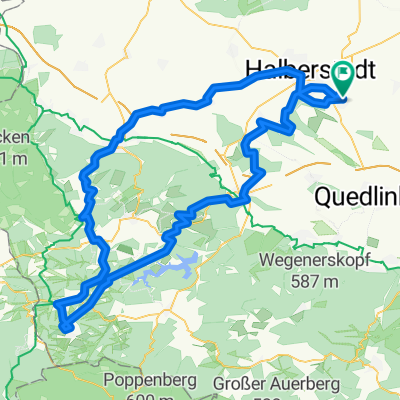
Von Harsleben über Ditfurt und Lehhof nach Quedlinburg. Weiter fahren wir am Praktiker-Baumarkt (Richtung Gernrode) durch die Gartensparten Holzbreite nach Quarmbeck. Von dort geht es weiter über die die Ausflugsgaststätte Bückemühle, Gernrode und das Hagental hinauf zum Bremer Teich. Über das Bären-Denkmal, Feriencamp Märchewiese, queren das Ulenbach-Tal und Bärenrode kommen wir nachGüntersberge. Ab hier fahren nur noch links oder rechts das Selke-Tal hinab (Straßberg, Silberhütte, Alexisbad, Mägdesprung, Selke Mühle) bis nach Meisdorf. Weiter führt uns die Tour über Ballenstedt zum Verkehrslandeplatz Asmusstedt. Von hier biegen wir links hinter dem Flugplatz Richtung Gersdorfer Burg ab und fahren über Quedlinburg und Ditfurt (Kiesgrube) ans Ziel.
- -:--
- Duration
- 105.4 km
- Distance
- 512 m
- Ascent
- 512 m
- Descent
- ---
- Avg. speed
- ---
- Avg. speed

Continue with Bikemap
Use, edit, or download this cycling route
You would like to ride Harsleben Bremer Teich-Güntersberge-Selketal-Ballenstedt or customize it for your own trip? Here is what you can do with this Bikemap route:
Free features
- Save this route as favorite or in collections
- Copy & plan your own version of this route
- Sync your route with Garmin or Wahoo
Premium features
Free trial for 3 days, or one-time payment. More about Bikemap Premium.
- Navigate this route on iOS & Android
- Export a GPX / KML file of this route
- Create your custom printout (try it for free)
- Download this route for offline navigation
Discover more Premium features.
Get Bikemap PremiumFrom our community
Other popular routes starting in Harsleben
 Foto-Tour Vorharz
- Distance
- 61.1 km
- Ascent
- 365 m
- Descent
- 366 m
- Location
- Harsleben, Saxony-Anhalt, Germany
 Hochwasser-Tour 27.7.17
- Distance
- 47 km
- Ascent
- 102 m
- Descent
- 102 m
- Location
- Harsleben, Saxony-Anhalt, Germany
 Transall - Ballenstedt
- Distance
- 98.1 km
- Ascent
- 577 m
- Descent
- 577 m
- Location
- Harsleben, Saxony-Anhalt, Germany
 Kaffeefahrt zur Roten Mühle
- Distance
- 64.9 km
- Ascent
- 493 m
- Descent
- 497 m
- Location
- Harsleben, Saxony-Anhalt, Germany
 Oberharz-Tour
- Distance
- 183.7 km
- Ascent
- 990 m
- Descent
- 990 m
- Location
- Harsleben, Saxony-Anhalt, Germany
 Unterharz - Tour
- Distance
- 102.5 km
- Ascent
- 651 m
- Descent
- 650 m
- Location
- Harsleben, Saxony-Anhalt, Germany
 Die Lange
- Distance
- 111.7 km
- Ascent
- 728 m
- Descent
- 727 m
- Location
- Harsleben, Saxony-Anhalt, Germany
 Brocken bis Selketal
- Distance
- 167.4 km
- Ascent
- 1,269 m
- Descent
- 1,269 m
- Location
- Harsleben, Saxony-Anhalt, Germany
Open it in the app