
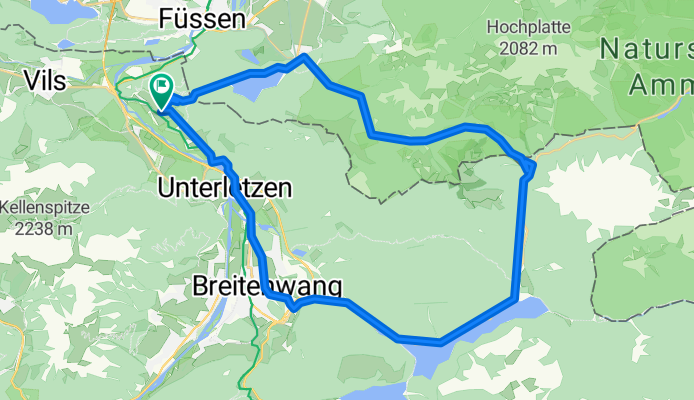
Rund um den Säuling
A cycling route starting in Musau, Tyrol, Austria.
Overview
About this route
Start in Unterpinswang-Auf geschottertem Forstweg bergan Richtung Alpsee- unterhalb von Schloss Hohenschwangau in Richtung Marienbrücke auf geteertem Waldweg-ab Marienbrücke in Richtung Bleckenau (Fahrweg rechte Talseite)steil ansteigend danach bis Alpe Bleckenau nur leicht ansteigend)- ab Blecken
- -:--
- Duration
- 37.3 km
- Distance
- 847 m
- Ascent
- 778 m
- Descent
- ---
- Avg. speed
- 1,424 m
- Avg. speed
Route quality
Waytypes & surfaces along the route
Waytypes
Busy road
15.2 km
(41 %)
Quiet road
8.7 km
(23 %)
Surfaces
Paved
23.4 km
(63 %)
Unpaved
8.8 km
(24 %)
Asphalt
23.4 km
(63 %)
Gravel
4.7 km
(13 %)
Continue with Bikemap
Use, edit, or download this cycling route
You would like to ride Rund um den Säuling or customize it for your own trip? Here is what you can do with this Bikemap route:
Free features
- Save this route as favorite or in collections
- Copy & plan your own version of this route
- Sync your route with Garmin or Wahoo
Premium features
Free trial for 3 days, or one-time payment. More about Bikemap Premium.
- Navigate this route on iOS & Android
- Export a GPX / KML file of this route
- Create your custom printout (try it for free)
- Download this route for offline navigation
Discover more Premium features.
Get Bikemap PremiumFrom our community
Other popular routes starting in Musau
 Rund um den Säuling
- Distance
- 37.3 km
- Ascent
- 847 m
- Descent
- 778 m
- Location
- Musau, Tyrol, Austria
 FÜssen-Namlos-Füssen
- Distance
- 101.7 km
- Ascent
- 1,062 m
- Descent
- 1,073 m
- Location
- Musau, Tyrol, Austria
 CICLOTOUR 2015 01 RENO DA FUSSEN
- Distance
- 1,220.3 km
- Ascent
- 229 m
- Descent
- 1,045 m
- Location
- Musau, Tyrol, Austria
 Füssen - Limone
- Distance
- 349 km
- Ascent
- 1,595 m
- Descent
- 2,319 m
- Location
- Musau, Tyrol, Austria
 Furtwangen Immenstadt letzte Etappe bis Ziel
- Distance
- 73.2 km
- Ascent
- 660 m
- Descent
- 743 m
- Location
- Musau, Tyrol, Austria
 Fussen II AE
- Distance
- 58.7 km
- Ascent
- 412 m
- Descent
- 418 m
- Location
- Musau, Tyrol, Austria
 Otto Mayr Hütte
- Distance
- 25.7 km
- Ascent
- 770 m
- Descent
- 773 m
- Location
- Musau, Tyrol, Austria
 imst 1
- Distance
- 59.4 km
- Ascent
- 1,084 m
- Descent
- 1,114 m
- Location
- Musau, Tyrol, Austria
Open it in the app