

Jura Krakowsko-Częstochowska
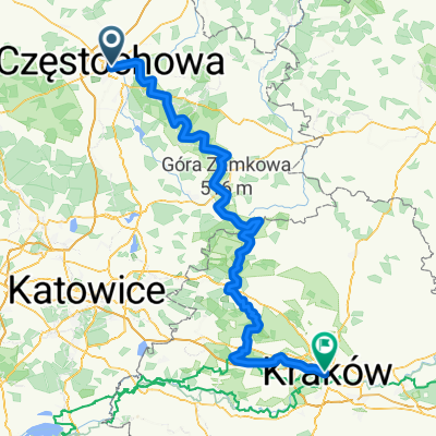
A cycling route starting in Częstochowa, Silesian Voivodeship, Poland.
Overview
About this route
- -:--
- Duration
- 210.7 km
- Distance
- 2,327 m
- Ascent
- 2,358 m
- Descent
- ---
- Avg. speed
- ---
- Avg. speed

Route quality
Waytypes & surfaces along the route
Waytypes
Quiet road
66 km
(31 %)
Track
60.1 km
(29 %)
Surfaces
Paved
134.4 km
(64 %)
Unpaved
50.6 km
(24 %)
Asphalt
118 km
(56 %)
Ground
18.7 km
(9 %)
Route highlights
Points of interest along the route

Point of interest after 1.6 km
Jasna Góra

Point of interest after 19.1 km
Góry Towarne

Point of interest after 21.9 km
Zamek Olsztyn
Point of interest after 22.3 km
Drewniany spichlerz w Olsztynie - Restauracja Spichlerz

Point of interest after 31.3 km
Pustynia Siedlecka

Point of interest after 38.3 km
Park pałacowy Krasińskich w Złotym Potoku

Point of interest after 40.1 km
Jaskinia Grota Niedźwiedzia w Złotym Potoku

Point of interest after 40.3 km
Młyn wodny Kołaczew w Złotym Potoku

Point of interest after 41.6 km
Dawna pstrągarnia Raczyńskich w Złotym Potoku

Point of interest after 41.8 km
Dolina Wiercicy - Złoty Potok

Point of interest after 41.9 km
Brama Twardowskiego w Złotym Potoku

Point of interest after 42.2 km
Diabelskie Mosty w Złotym Potoku

Point of interest after 43.5 km
Zamek „Ostrężnik” w rezerwacie przyrody

Point of interest after 46.5 km
Ruiny strażnicy obronnej w Przewodziszowicach

Point of interest after 49.5 km
Zespół stodół w Żarkach

Point of interest after 58.2 km
Zamek Mirów

Point of interest after 58.7 km
Grzęda Mirowska

Point of interest after 59.5 km
Zamek Bobolice

Point of interest after 120.7 km
Czubatka

Point of interest after 121.5 km
Platforma widokowa

Point of interest after 122.5 km
Pustynia Błędowska - Róża Wiatrów

Point of interest after 123.4 km
Schron obserwacyjny

Point of interest after 135.3 km
Schron obserwacyjny

Point of interest after 137.7 km
Punkt widokowy

Point of interest after 138.2 km
Punkt widokowy Dąbrówka
Continue with Bikemap
Use, edit, or download this cycling route
You would like to ride Jura Krakowsko-Częstochowska or customize it for your own trip? Here is what you can do with this Bikemap route:
Free features
- Save this route as favorite or in collections
- Copy & plan your own version of this route
- Sync your route with Garmin or Wahoo
Premium features
Free trial for 3 days, or one-time payment. More about Bikemap Premium.
- Navigate this route on iOS & Android
- Export a GPX / KML file of this route
- Create your custom printout (try it for free)
- Download this route for offline navigation
Discover more Premium features.
Get Bikemap PremiumFrom our community
Other popular routes starting in Częstochowa
 Jurajski Szlak Rowerowy Orlich Gniazd
- Distance
- 177.7 km
- Ascent
- 766 m
- Descent
- 798 m
- Location
- Częstochowa, Silesian Voivodeship, Poland
 SOGp
SOGp- Distance
- 157.2 km
- Ascent
- 586 m
- Descent
- 623 m
- Location
- Częstochowa, Silesian Voivodeship, Poland
 Szlak Orlich Gniazd
- Distance
- 184.3 km
- Ascent
- 769 m
- Descent
- 812 m
- Location
- Częstochowa, Silesian Voivodeship, Poland
 Czestochowa-Dubrovnik
- Distance
- 1,358.7 km
- Ascent
- 2,201 m
- Descent
- 2,399 m
- Location
- Częstochowa, Silesian Voivodeship, Poland
 Mirów
Mirów- Distance
- 39.4 km
- Ascent
- 106 m
- Descent
- 103 m
- Location
- Częstochowa, Silesian Voivodeship, Poland
 Częstochowa - Folwark Kamyk - Częstochowa 26,2 km
- Distance
- 26.2 km
- Ascent
- 86 m
- Descent
- 86 m
- Location
- Częstochowa, Silesian Voivodeship, Poland
 Embajka w jurze
- Distance
- 208.3 km
- Ascent
- 885 m
- Descent
- 920 m
- Location
- Częstochowa, Silesian Voivodeship, Poland
 szlak orlich gniazd
- Distance
- 247 km
- Ascent
- 1,079 m
- Descent
- 1,122 m
- Location
- Częstochowa, Silesian Voivodeship, Poland
Open it in the app