
Ruta relajada en cicla alto de rosas
A cycling route starting in Sibaté, Cundinamarca, Colombia.
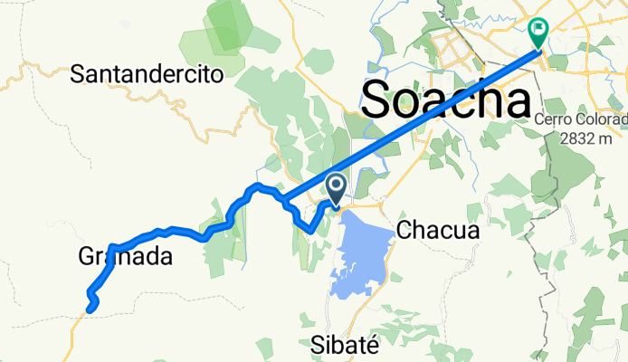
Overview
About this route
- 3 h 32 min
- Duration
- 30.8 km
- Distance
- 1,807 m
- Ascent
- 1,690 m
- Descent
- 8.7 km/h
- Avg. speed
- ---
- Avg. speed

Continue with Bikemap
Use, edit, or download this cycling route
You would like to ride Ruta relajada en cicla alto de rosas or customize it for your own trip? Here is what you can do with this Bikemap route:
Free features
- Save this route as favorite or in collections
- Copy & plan your own version of this route
- Sync your route with Garmin or Wahoo
Premium features
Free trial for 3 days, or one-time payment. More about Bikemap Premium.
- Navigate this route on iOS & Android
- Export a GPX / KML file of this route
- Create your custom printout (try it for free)
- Download this route for offline navigation
Discover more Premium features.
Get Bikemap PremiumFrom our community
Other popular routes starting in Sibaté
 El tzueño cumplio'
- Distance
- 130.5 km
- Ascent
- 1,195 m
- Descent
- 3,479 m
- Location
- Sibaté, Cundinamarca, Colombia
 Sendero del frailejón
- Distance
- 22.4 km
- Ascent
- 469 m
- Descent
- 1,023 m
- Location
- Sibaté, Cundinamarca, Colombia
 alto de Romeral
- Distance
- 10.9 km
- Ascent
- 888 m
- Descent
- 133 m
- Location
- Sibaté, Cundinamarca, Colombia
 Ruta relajada en cicla alto de rosas
- Distance
- 30.8 km
- Ascent
- 1,807 m
- Descent
- 1,690 m
- Location
- Sibaté, Cundinamarca, Colombia
 Paseo rápido en Sibaté
- Distance
- 8.5 km
- Ascent
- 223 m
- Descent
- 46 m
- Location
- Sibaté, Cundinamarca, Colombia
 El Romeral - Tibacuy - Quininí - Pueblo Nuevo - Agua de dios - Tocaima
- Distance
- 84.2 km
- Ascent
- 857 m
- Descent
- 3,260 m
- Location
- Sibaté, Cundinamarca, Colombia
 ANILLO SUMAPAZ2
- Distance
- 85.2 km
- Ascent
- 6,079 m
- Descent
- 6,134 m
- Location
- Sibaté, Cundinamarca, Colombia
 sábado 🚵🚵🚵🚵
- Distance
- 32 km
- Ascent
- 776 m
- Descent
- 765 m
- Location
- Sibaté, Cundinamarca, Colombia
Open it in the app