

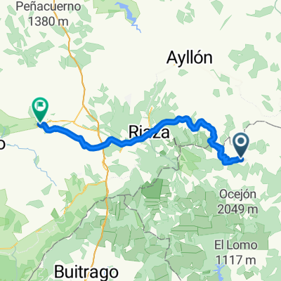
ruta 2
A cycling route starting in Cantalojas, Castille-La Mancha, Spain.
Overview
About this route
- 2 h
- Duration
- 9.1 km
- Distance
- 158 m
- Ascent
- 204 m
- Descent
- 4.5 km/h
- Avg. speed
- ---
- Avg. speed
Continue with Bikemap
Use, edit, or download this cycling route
You would like to ride ruta 2 or customize it for your own trip? Here is what you can do with this Bikemap route:
Free features
- Save this route as favorite or in collections
- Copy & plan your own version of this route
- Sync your route with Garmin or Wahoo
Premium features
Free trial for 3 days, or one-time payment. More about Bikemap Premium.
- Navigate this route on iOS & Android
- Export a GPX / KML file of this route
- Create your custom printout (try it for free)
- Download this route for offline navigation
Discover more Premium features.
Get Bikemap PremiumFrom our community
Other popular routes starting in Cantalojas
 cantalojas sepulveda
- Distance
- 62.1 km
- Ascent
- 584 m
- Descent
- 902 m
- Location
- Cantalojas, Castille-La Mancha, Spain
 Grado de Pico
- Distance
- 35.7 km
- Ascent
- 611 m
- Descent
- 607 m
- Location
- Cantalojas, Castille-La Mancha, Spain
 Río Zarzas Cantalojas
- Distance
- 24.9 km
- Ascent
- 638 m
- Descent
- 521 m
- Location
- Cantalojas, Castille-La Mancha, Spain
 D0330 Cantalojas - Retortillo de Soria
- Distance
- 34.4 km
- Ascent
- 434 m
- Descent
- 548 m
- Location
- Cantalojas, Castille-La Mancha, Spain
 Cantalojas-Montejo
- Distance
- 53.7 km
- Ascent
- 418 m
- Descent
- 575 m
- Location
- Cantalojas, Castille-La Mancha, Spain
 Cantalojas Majaelrayo
- Distance
- 22.9 km
- Ascent
- 557 m
- Descent
- 679 m
- Location
- Cantalojas, Castille-La Mancha, Spain
 cantalojas-montejo de tiermes
- Distance
- 53.2 km
- Ascent
- 412 m
- Descent
- 573 m
- Location
- Cantalojas, Castille-La Mancha, Spain
 Hayedo de Tejera Negra - Campisábalos - Galve de Sorbe
- Distance
- 73 km
- Ascent
- 644 m
- Descent
- 709 m
- Location
- Cantalojas, Castille-La Mancha, Spain
Open it in the app