

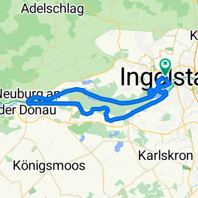
Ingolstadt-Geisenfeld
A cycling route starting in Ingolstadt, Bavaria, Germany.
Overview
About this route
Ingolstadt, Elbrachtstr. (P)
Geisenfeld: Restaurant Maximilian's Ruhetag: Montag
- 3 h 48 min
- Duration
- 61.6 km
- Distance
- 184 m
- Ascent
- 184 m
- Descent
- 16.2 km/h
- Avg. speed
- 465 m
- Avg. speed

Route quality
Waytypes & surfaces along the route
Waytypes
Quiet road
18.4 km
(30 %)
Track
13.9 km
(23 %)
Surfaces
Paved
33.4 km
(54 %)
Unpaved
16.6 km
(27 %)
Asphalt
27.4 km
(44 %)
Gravel
14.5 km
(24 %)
Route highlights
Points of interest along the route
Accommodation after 27.1 km
Maximilian's
Continue with Bikemap
Use, edit, or download this cycling route
You would like to ride Ingolstadt-Geisenfeld or customize it for your own trip? Here is what you can do with this Bikemap route:
Free features
- Save this route as favorite or in collections
- Copy & plan your own version of this route
- Sync your route with Garmin or Wahoo
Premium features
Free trial for 3 days, or one-time payment. More about Bikemap Premium.
- Navigate this route on iOS & Android
- Export a GPX / KML file of this route
- Create your custom printout (try it for free)
- Download this route for offline navigation
Discover more Premium features.
Get Bikemap PremiumFrom our community
Other popular routes starting in Ingolstadt
 ingolstadt - münchen
- Distance
- 94.8 km
- Ascent
- 415 m
- Descent
- 294 m
- Location
- Ingolstadt, Bavaria, Germany
 OstRunde - Geisenfeld- Führholzen -Adelsberg
- Distance
- 49.5 km
- Ascent
- 110 m
- Descent
- 112 m
- Location
- Ingolstadt, Bavaria, Germany
 16. Ingolstadt-Finningen (Mörslingen)
- Distance
- 96 km
- Ascent
- 396 m
- Descent
- 335 m
- Location
- Ingolstadt, Bavaria, Germany
 Neuburgtour 8/2010
- Distance
- 47.7 km
- Ascent
- 61 m
- Descent
- 61 m
- Location
- Ingolstadt, Bavaria, Germany
 Birkenheide Tour 8/2010
- Distance
- 45.5 km
- Ascent
- 56 m
- Descent
- 56 m
- Location
- Ingolstadt, Bavaria, Germany
 Kurzes Training
- Distance
- 14.8 km
- Ascent
- 12 m
- Descent
- 8 m
- Location
- Ingolstadt, Bavaria, Germany
 Tour de Houblon 2013
- Distance
- 94.5 km
- Ascent
- 275 m
- Descent
- 274 m
- Location
- Ingolstadt, Bavaria, Germany
 Schmetterlingsweg im Altmühltal
- Distance
- 120 km
- Ascent
- 1,048 m
- Descent
- 1,000 m
- Location
- Ingolstadt, Bavaria, Germany
Open it in the app