
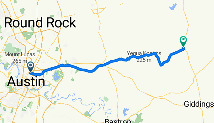
4810 Avenue H, Austin to 601–681 N Rockdale St, Lexington
A cycling route starting in Austin, Texas, United States of America.
Overview
About this route
- 4 h 46 min
- Duration
- 83.8 km
- Distance
- 465 m
- Ascent
- 523 m
- Descent
- 17.6 km/h
- Avg. speed
- ---
- Avg. speed

Route quality
Waytypes & surfaces along the route
Waytypes
Road
33.4 km
(40 %)
Quiet road
22.4 km
(27 %)
Surfaces
Paved
28.9 km
(34 %)
Unpaved
1.7 km
(2 %)
Asphalt
24.1 km
(29 %)
Concrete
4.5 km
(5 %)
Continue with Bikemap
Use, edit, or download this cycling route
You would like to ride 4810 Avenue H, Austin to 601–681 N Rockdale St, Lexington or customize it for your own trip? Here is what you can do with this Bikemap route:
Free features
- Save this route as favorite or in collections
- Copy & plan your own version of this route
- Sync your route with Garmin or Wahoo
Premium features
Free trial for 3 days, or one-time payment. More about Bikemap Premium.
- Navigate this route on iOS & Android
- Export a GPX / KML file of this route
- Create your custom printout (try it for free)
- Download this route for offline navigation
Discover more Premium features.
Get Bikemap PremiumFrom our community
Other popular routes starting in Austin
 Woodrow Ave, Austin to Woodrow Ave, Austin
- Distance
- 5.5 km
- Ascent
- 22 m
- Descent
- 30 m
- Location
- Austin, Texas, United States of America
 McKinney Falls
- Distance
- 40.9 km
- Ascent
- 231 m
- Descent
- 232 m
- Location
- Austin, Texas, United States of America
 N IH-35 Service Rd, Austin to IH-35 N, Austin
- Distance
- 20.7 km
- Ascent
- 138 m
- Descent
- 133 m
- Location
- Austin, Texas, United States of America
 Bee Cave
- Distance
- 89.9 km
- Ascent
- 452 m
- Descent
- 452 m
- Location
- Austin, Texas, United States of America
 Austin - Circle on Mostly Bike Routes
- Distance
- 38.4 km
- Ascent
- 471 m
- Descent
- 471 m
- Location
- Austin, Texas, United States of America
 East Side 6er
- Distance
- 10 km
- Ascent
- 308 m
- Descent
- 339 m
- Location
- Austin, Texas, United States of America
 Southwest Parkway
- Distance
- 50.3 km
- Ascent
- 383 m
- Descent
- 383 m
- Location
- Austin, Texas, United States of America
 Gentleman's Ride
- Distance
- 49 km
- Ascent
- 463 m
- Descent
- 464 m
- Location
- Austin, Texas, United States of America
Open it in the app