

Von Völlan nach St.Hippolyt
A cycling route starting in Lana, Trentino-Alto Adige, Italy.
Overview
About this route
Diese aussichtsreiche Tour ist ideal für alle, die eine kleine und nicht allzu schwierige Runde mit dem Bike machen möchten.
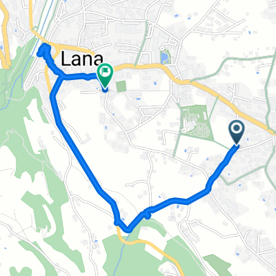
Die Tour beginnt direkt bei unserem Hotel. Wir fahren in Richtung Dorfzentrum und biegen auf den asphaltierten Weg in Richtung Völlaner Badl ab. Bald wechselt der Untergrund von Asphalt auf Schotter. Beim Völlaner Badl biegen wir rechts ab und folgen der asphaltierten Straße, vorbei am Hofstätter Hof (Ausschank) bis hin zur Gampenstraße. Wir folgen der Straße ca. 500m und biegen dann vor einem Tunnel links in den Parkplatz von St.Hippolyt ein. Hier folgen wir immer den Forstweg, der uns immer steiler zum Kirchlein St.Hippolyt führt (Ausschank). Das geniale Panorama lädt zum Genießen ein! Auf dem Rückweg folgen wir dem Forstweg wieder bis zum Parkplatz, fahren rechts die Straße in Richtung Tankstelle und biegen nach der Tankstelle rechts ein. Dem Weg bringt uns vorbei am Gasthaus Talmühle direkt wieder nach Völlan. Achtung, der Schotterweg kann beim Abfahren rutschig sein.
- -:--
- Duration
- 11.3 km
- Distance
- 383 m
- Ascent
- 386 m
- Descent
- ---
- Avg. speed
- ---
- Avg. speed

Route quality
Waytypes & surfaces along the route
Waytypes
Track
4.3 km
(38 %)
Quiet road
2.7 km
(24 %)
Surfaces
Paved
4 km
(35 %)
Unpaved
4.8 km
(42 %)
Asphalt
4 km
(35 %)
Gravel
2.6 km
(23 %)
Continue with Bikemap
Use, edit, or download this cycling route
You would like to ride Von Völlan nach St.Hippolyt or customize it for your own trip? Here is what you can do with this Bikemap route:
Free features
- Save this route as favorite or in collections
- Copy & plan your own version of this route
- Sync your route with Garmin or Wahoo
Premium features
Free trial for 3 days, or one-time payment. More about Bikemap Premium.
- Navigate this route on iOS & Android
- Export a GPX / KML file of this route
- Create your custom printout (try it for free)
- Download this route for offline navigation
Discover more Premium features.
Get Bikemap PremiumFrom our community
Other popular routes starting in Lana
 Lana Meran
- Distance
- 31.1 km
- Ascent
- 112 m
- Descent
- 112 m
- Location
- Lana, Trentino-Alto Adige, Italy
 Lana-Meran-Lana
- Distance
- 42.1 km
- Ascent
- 481 m
- Descent
- 483 m
- Location
- Lana, Trentino-Alto Adige, Italy
 I 008: Überetsch
- Distance
- 43.4 km
- Ascent
- 191 m
- Descent
- 190 m
- Location
- Lana, Trentino-Alto Adige, Italy
 Mayenburgstraße 32, Völlan nach Mayenburgstraße 32, Völlan
- Distance
- 19.3 km
- Ascent
- 1,596 m
- Descent
- 1,601 m
- Location
- Lana, Trentino-Alto Adige, Italy
 Lana, Tesimo, Nalles, Lana 26.3Km 450Hm
- Distance
- 26.3 km
- Ascent
- 433 m
- Descent
- 434 m
- Location
- Lana, Trentino-Alto Adige, Italy
 Mendel & Hafling
- Distance
- 148.8 km
- Ascent
- 3,086 m
- Descent
- 3,086 m
- Location
- Lana, Trentino-Alto Adige, Italy
 Goldeggstraße, Lana nach Kapuzinerstraße, Lana
- Distance
- 2.4 km
- Ascent
- 91 m
- Descent
- 70 m
- Location
- Lana, Trentino-Alto Adige, Italy
 Lana - Meran - Lana
- Distance
- 40.1 km
- Ascent
- 392 m
- Descent
- 394 m
- Location
- Lana, Trentino-Alto Adige, Italy
Open it in the app