

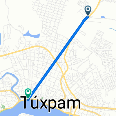
De Túxpam de Rodríguez Cano a Manuel C. Tello 23, Túxpam de Rodríguez Cano
A cycling route starting in Banderas, Veracruz, Mexico.
Overview
About this route
- 46 min
- Duration
- 24.2 km
- Distance
- 11 m
- Ascent
- 2 m
- Descent
- 31.7 km/h
- Avg. speed
- ---
- Avg. speed

Continue with Bikemap
Use, edit, or download this cycling route
You would like to ride De Túxpam de Rodríguez Cano a Manuel C. Tello 23, Túxpam de Rodríguez Cano or customize it for your own trip? Here is what you can do with this Bikemap route:
Free features
- Save this route as favorite or in collections
- Copy & plan your own version of this route
- Sync your route with Garmin or Wahoo
Premium features
Free trial for 3 days, or one-time payment. More about Bikemap Premium.
- Navigate this route on iOS & Android
- Export a GPX / KML file of this route
- Create your custom printout (try it for free)
- Download this route for offline navigation
Discover more Premium features.
Get Bikemap PremiumFrom our community
Other popular routes starting in Banderas
 De Túxpam de Rodríguez Cano a Manuel C. Tello 23, Túxpam de Rodríguez Cano
- Distance
- 24.2 km
- Ascent
- 11 m
- Descent
- 2 m
- Location
- Banderas, Veracruz, Mexico
 De A Tamiahua 20, Túxpam de Rodríguez Cano a Carretera Federal 180 57, Túxpam de Rodríguez Cano
- Distance
- 2.8 km
- Ascent
- 0 m
- Descent
- 0 m
- Location
- Banderas, Veracruz, Mexico
 de regreso a la aventura
- Distance
- 23.9 km
- Ascent
- 1 m
- Descent
- 1 m
- Location
- Banderas, Veracruz, Mexico
 De Manuel C. Tello 25, Túxpam de Rodríguez Cano a Manuel C. Tello 11, Túxpam de Rodríguez Cano
- Distance
- 11.4 km
- Ascent
- 0 m
- Descent
- 0 m
- Location
- Banderas, Veracruz, Mexico
Open it in the app