

2012-2
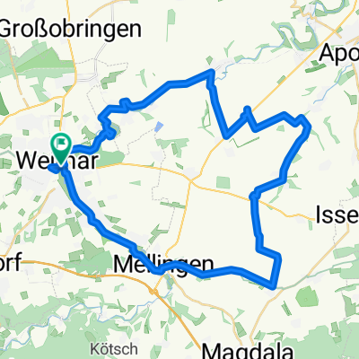
A cycling route starting in Weimar, Free State of Thuringia, Germany.
Overview
About this route
- -:--
- Duration
- 71.7 km
- Distance
- 320 m
- Ascent
- 408 m
- Descent
- ---
- Avg. speed
- ---
- Avg. speed

Route quality
Waytypes & surfaces along the route
Waytypes
Busy road
43.8 km
(61 %)
Path
11.3 km
(16 %)
Surfaces
Paved
59.1 km
(82 %)
Unpaved
2.2 km
(3 %)
Asphalt
51.3 km
(72 %)
Paving stones
4.4 km
(6 %)
Continue with Bikemap
Use, edit, or download this cycling route
You would like to ride 2012-2 or customize it for your own trip? Here is what you can do with this Bikemap route:
Free features
- Save this route as favorite or in collections
- Copy & plan your own version of this route
- Sync your route with Garmin or Wahoo
Premium features
Free trial for 3 days, or one-time payment. More about Bikemap Premium.
- Navigate this route on iOS & Android
- Export a GPX / KML file of this route
- Create your custom printout (try it for free)
- Download this route for offline navigation
Discover more Premium features.
Get Bikemap PremiumFrom our community
Other popular routes starting in Weimar
 Rundtour um Weimar
- Distance
- 41.2 km
- Ascent
- 241 m
- Descent
- 249 m
- Location
- Weimar, Free State of Thuringia, Germany
 Weimar Idee 2
- Distance
- 36.1 km
- Ascent
- 425 m
- Descent
- 426 m
- Location
- Weimar, Free State of Thuringia, Germany
 Ilmtalwanderweg
- Distance
- 59.4 km
- Ascent
- 432 m
- Descent
- 170 m
- Location
- Weimar, Free State of Thuringia, Germany
 13.04.10 Weimar-Köttendorf-Bad Berka Waldstrecke
- Distance
- 33.1 km
- Ascent
- 453 m
- Descent
- 417 m
- Location
- Weimar, Free State of Thuringia, Germany
 Friedensradfahrt 2009 Paris - Moskau 15. Etappe Weimar - Bad Sulza am 20. Juli 2009
- Distance
- 29.1 km
- Ascent
- 192 m
- Descent
- 260 m
- Location
- Weimar, Free State of Thuringia, Germany
 06.04.10 Jena-Tour mit Flo+Seb
- Distance
- 57 km
- Ascent
- 862 m
- Descent
- 819 m
- Location
- Weimar, Free State of Thuringia, Germany
 Feierabendrunde Weimar Nord/West
- Distance
- 36.9 km
- Ascent
- 463 m
- Descent
- 438 m
- Location
- Weimar, Free State of Thuringia, Germany
 RFV 1990 Weimar 'Rund um Weimar' permanent
- Distance
- 74.9 km
- Ascent
- 634 m
- Descent
- 634 m
- Location
- Weimar, Free State of Thuringia, Germany
Open it in the app