

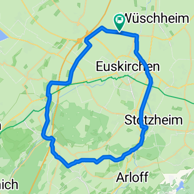
EU - Ruine Wensburg - EU
A cycling route starting in Euskirchen, North Rhine-Westphalia, Germany.
Overview
About this route
Ausgehend von Euskirchen über die Steinbachtalsperre und das Eifelteleskop zur Ruine Wensburg (wo man nur zu Fuß die Ruine besichtigen kann), dann durch den Wald auf die Höhe bei Harscheid und über die Höhen bis zur Wasserscheide zwischen Schuld und Bad Münstereifel. Von da aus über den normalen Weg zurück.
- -:--
- Duration
- 69.7 km
- Distance
- 1,088 m
- Ascent
- 944 m
- Descent
- ---
- Avg. speed
- 518 m
- Avg. speed

Route quality
Waytypes & surfaces along the route
Waytypes
Quiet road
17.2 km
(25 %)
Road
16.5 km
(24 %)
Surfaces
Paved
46.5 km
(67 %)
Unpaved
6.1 km
(9 %)
Asphalt
44 km
(63 %)
Gravel
2.7 km
(4 %)
Continue with Bikemap
Use, edit, or download this cycling route
You would like to ride EU - Ruine Wensburg - EU or customize it for your own trip? Here is what you can do with this Bikemap route:
Free features
- Save this route as favorite or in collections
- Copy & plan your own version of this route
- Sync your route with Garmin or Wahoo
Premium features
Free trial for 3 days, or one-time payment. More about Bikemap Premium.
- Navigate this route on iOS & Android
- Export a GPX / KML file of this route
- Create your custom printout (try it for free)
- Download this route for offline navigation
Discover more Premium features.
Get Bikemap PremiumFrom our community
Other popular routes starting in Euskirchen
 Kloster Schweinheim
- Distance
- 21.5 km
- Ascent
- 134 m
- Descent
- 136 m
- Location
- Euskirchen, North Rhine-Westphalia, Germany
 EU-BAM-Forstgebiete-Arloff-EU
- Distance
- 39.1 km
- Ascent
- 290 m
- Descent
- 291 m
- Location
- Euskirchen, North Rhine-Westphalia, Germany
 MTB tour der hoffnung ca. 48KM 800HM
- Distance
- 47.5 km
- Ascent
- 682 m
- Descent
- 689 m
- Location
- Euskirchen, North Rhine-Westphalia, Germany
 Rund um Euskirchen
- Distance
- 28.7 km
- Ascent
- 122 m
- Descent
- 117 m
- Location
- Euskirchen, North Rhine-Westphalia, Germany
 2025_2 Euskirchen bis Aachen
- Distance
- 74.2 km
- Ascent
- 716 m
- Descent
- 700 m
- Location
- Euskirchen, North Rhine-Westphalia, Germany
 Rund um den Billiger Wald
- Distance
- 29.4 km
- Ascent
- 131 m
- Descent
- 131 m
- Location
- Euskirchen, North Rhine-Westphalia, Germany
 Von EU ums BM-Tal
- Distance
- 35.6 km
- Ascent
- 415 m
- Descent
- 423 m
- Location
- Euskirchen, North Rhine-Westphalia, Germany
 EU-Abendroute (westlich EU)
- Distance
- 20.4 km
- Ascent
- 93 m
- Descent
- 91 m
- Location
- Euskirchen, North Rhine-Westphalia, Germany
Open it in the app