

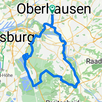
Kleine Runde Ruhrpark- Mülheim
A cycling route starting in Oberhausen, North Rhine-Westphalia, Germany.
Overview
About this route
Ab Ruhrpark nach Mülheim über Sportplatz Storchenturm an der Ruhr entlang etwas wellig. Kettwig runter über Mintrad zurück durch die ehm. MÜGA
- -:--
- Duration
- 34 km
- Distance
- 232 m
- Ascent
- 223 m
- Descent
- ---
- Avg. speed
- 98 m
- Avg. speed

Route quality
Waytypes & surfaces along the route
Waytypes
Busy road
18.7 km
(55 %)
Path
7.6 km
(22 %)
Surfaces
Paved
29.8 km
(88 %)
Unpaved
1.5 km
(5 %)
Asphalt
26.6 km
(78 %)
Paving stones
2.7 km
(8 %)
Continue with Bikemap
Use, edit, or download this cycling route
You would like to ride Kleine Runde Ruhrpark- Mülheim or customize it for your own trip? Here is what you can do with this Bikemap route:
Free features
- Save this route as favorite or in collections
- Copy & plan your own version of this route
- Sync your route with Garmin or Wahoo
Premium features
Free trial for 3 days, or one-time payment. More about Bikemap Premium.
- Navigate this route on iOS & Android
- Export a GPX / KML file of this route
- Create your custom printout (try it for free)
- Download this route for offline navigation
Discover more Premium features.
Get Bikemap PremiumFrom our community
Other popular routes starting in Oberhausen
 Centro, Rotbach, Voerde, Walsum, Centro
- Distance
- 54 km
- Ascent
- 159 m
- Descent
- 167 m
- Location
- Oberhausen, North Rhine-Westphalia, Germany
 schöne Feierabendrunde
- Distance
- 37.4 km
- Ascent
- 200 m
- Descent
- 200 m
- Location
- Oberhausen, North Rhine-Westphalia, Germany
 Olga - Grafenmühle - Schermbeck - Weselerwald - Hünxe - Fridrichsfeld - Götterswickerham - Möllen - Pillekamp - Grafschaft - Schmachtendorf - Eisenheim
- Distance
- 95.4 km
- Ascent
- 184 m
- Descent
- 186 m
- Location
- Oberhausen, North Rhine-Westphalia, Germany
 Kleine Runde um die Ruhr OB/DU/MH
- Distance
- 21.1 km
- Ascent
- 44 m
- Descent
- 42 m
- Location
- Oberhausen, North Rhine-Westphalia, Germany
 24 Haldentour vier Halden im Revier
- Distance
- 55.8 km
- Ascent
- 294 m
- Descent
- 294 m
- Location
- Oberhausen, North Rhine-Westphalia, Germany
 Olga - Gahlen - Drevenack - Wesel - Orsoy
- Distance
- 88 km
- Ascent
- 144 m
- Descent
- 145 m
- Location
- Oberhausen, North Rhine-Westphalia, Germany
 Centro - Amphiteater - Zollverein - Freibad Hesse - Gehölzgarten Ripshorst
- Distance
- 33.3 km
- Ascent
- 51 m
- Descent
- 48 m
- Location
- Oberhausen, North Rhine-Westphalia, Germany
 HOAG-Trasse - Kleine Emscher
- Distance
- 40.1 km
- Ascent
- 96 m
- Descent
- 96 m
- Location
- Oberhausen, North Rhine-Westphalia, Germany