

De Rua dos Cadavais 111 a Rua dos Cadavais 109
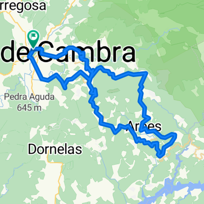
A cycling route starting in Vale de Cambra, Aveiro District, Portugal.
Overview
About this route
- 3 h 23 min
- Duration
- 62.8 km
- Distance
- 1,565 m
- Ascent
- 1,554 m
- Descent
- 18.6 km/h
- Avg. speed
- ---
- Avg. speed

Route quality
Waytypes & surfaces along the route
Waytypes
Busy road
42.5 km
(68 %)
Road
11.1 km
(18 %)
Surfaces
Paved
4.7 km
(8 %)
Asphalt
4.7 km
(8 %)
Undefined
58.1 km
(92 %)
Continue with Bikemap
Use, edit, or download this cycling route
You would like to ride De Rua dos Cadavais 111 a Rua dos Cadavais 109 or customize it for your own trip? Here is what you can do with this Bikemap route:
Free features
- Save this route as favorite or in collections
- Copy & plan your own version of this route
- Sync your route with Garmin or Wahoo
Premium features
Free trial for 3 days, or one-time payment. More about Bikemap Premium.
- Navigate this route on iOS & Android
- Export a GPX / KML file of this route
- Create your custom printout (try it for free)
- Download this route for offline navigation
Discover more Premium features.
Get Bikemap PremiumFrom our community
Other popular routes starting in Vale de Cambra
 De Rua dos Cadavais 111 a Rua dos Cadavais 109
- Distance
- 62.8 km
- Ascent
- 1,565 m
- Descent
- 1,554 m
- Location
- Vale de Cambra, Aveiro District, Portugal
 São Pedro do Sul
- Distance
- 109.1 km
- Ascent
- 2,946 m
- Descent
- 2,947 m
- Location
- Vale de Cambra, Aveiro District, Portugal
 De Rua do Gueide 167, Vale de Cambra a Rua do Gueide 167, Vale de Cambra
- Distance
- 49 km
- Ascent
- 1,259 m
- Descent
- 1,261 m
- Location
- Vale de Cambra, Aveiro District, Portugal
 voltinha da serra
- Distance
- 36.9 km
- Ascent
- 1,117 m
- Descent
- 1,117 m
- Location
- Vale de Cambra, Aveiro District, Portugal
 vdgh
vdgh- Distance
- 39.7 km
- Ascent
- 787 m
- Descent
- 1,009 m
- Location
- Vale de Cambra, Aveiro District, Portugal
 Free Trail da Castanha 2020 - Oficial
- Distance
- 14.3 km
- Ascent
- 895 m
- Descent
- 894 m
- Location
- Vale de Cambra, Aveiro District, Portugal
 volta pelas talhadas
- Distance
- 89.1 km
- Ascent
- 2,845 m
- Descent
- 2,845 m
- Location
- Vale de Cambra, Aveiro District, Portugal
 Vale de Cambra - São Macário por sSPSul
- Distance
- 129.3 km
- Ascent
- 2,187 m
- Descent
- 2,105 m
- Location
- Vale de Cambra, Aveiro District, Portugal
Open it in the app