

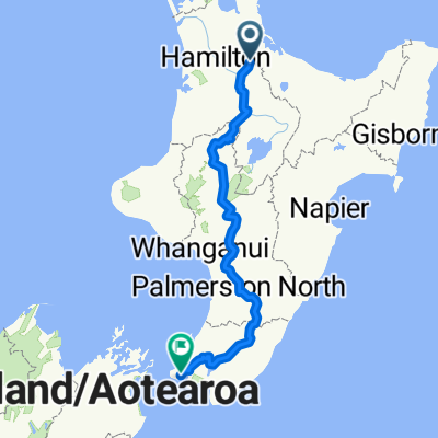
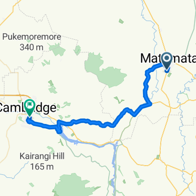
Matamata to home
A cycling route starting in Matamata, Waikato Region, New Zealand.
Overview
About this route
- -:--
- Duration
- 44 km
- Distance
- 242 m
- Ascent
- 234 m
- Descent
- ---
- Avg. speed
- 227 m
- Max. altitude

Route quality
Waytypes & surfaces along the route
Waytypes
Quiet road
25.9 km
(59 %)
Road
4.8 km
(11 %)
Surfaces
Paved
43.1 km
(98 %)
Paved (undefined)
22.4 km
(51 %)
Asphalt
20.7 km
(47 %)
Undefined
0.9 km
(2 %)
Continue with Bikemap
Use, edit, or download this cycling route
You would like to ride Matamata to home or customize it for your own trip? Here is what you can do with this Bikemap route:
Free features
- Save this route as favorite or in collections
- Copy & plan your own version of this route
- Sync your route with Garmin or Wahoo
Premium features
Free trial for 3 days, or one-time payment. More about Bikemap Premium.
- Navigate this route on iOS & Android
- Export a GPX / KML file of this route
- Create your custom printout (try it for free)
- Download this route for offline navigation
Discover more Premium features.
Get Bikemap PremiumFrom our community
Other popular routes starting in Matamata
 20110809 Matamata to Waihi
- Distance
- 87.4 km
- Ascent
- 236 m
- Descent
- 280 m
- Location
- Matamata, Waikato Region, New Zealand
 Matamata to home
- Distance
- 44 km
- Ascent
- 242 m
- Descent
- 234 m
- Location
- Matamata, Waikato Region, New Zealand
 NZ-North Island Matamata To Wellington
- Distance
- 678.4 km
- Ascent
- 2,090 m
- Descent
- 2,128 m
- Location
- Matamata, Waikato Region, New Zealand
 Matamata-Te Aroha
- Distance
- 37.1 km
- Ascent
- 33 m
- Descent
- 73 m
- Location
- Matamata, Waikato Region, New Zealand
 5 - Matamata - Mangakino - 80km
- Distance
- 75.8 km
- Ascent
- 521 m
- Descent
- 385 m
- Location
- Matamata, Waikato Region, New Zealand
 NZ Day 18 (Day 16 and 17 in Matamata)
- Distance
- 51.8 km
- Ascent
- 647 m
- Descent
- 154 m
- Location
- Matamata, Waikato Region, New Zealand
 Ride from Tim's house
- Distance
- 24.2 km
- Ascent
- 346 m
- Descent
- 346 m
- Location
- Matamata, Waikato Region, New Zealand
 Moderate route in Cambridge
- Distance
- 44.5 km
- Ascent
- 1,673 m
- Descent
- 1,559 m
- Location
- Matamata, Waikato Region, New Zealand
Open it in the app