

r202 ROAM
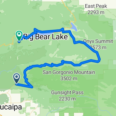
A cycling route starting in Yucaipa, California, United States of America.
Overview
About this route
mill creek rd.-angelus oaks-jenks lake-cienaga seca creek-onyx summit-deadmens lake-big bear city-big bear lake-fawnskin-groat bay-north fork bear creek
- -:--
- Duration
- 86.5 km
- Distance
- 1,898 m
- Ascent
- 956 m
- Descent
- ---
- Avg. speed
- ---
- Avg. speed
Route quality
Waytypes & surfaces along the route
Waytypes
Busy road
66.7 km
(77 %)
Quiet road
13.7 km
(16 %)
Surfaces
Paved
81 km
(94 %)
Unpaved
2.1 km
(2 %)
Asphalt
73.5 km
(85 %)
Paved (undefined)
7.5 km
(9 %)
Continue with Bikemap
Use, edit, or download this cycling route
You would like to ride r202 ROAM or customize it for your own trip? Here is what you can do with this Bikemap route:
Free features
- Save this route as favorite or in collections
- Copy & plan your own version of this route
- Sync your route with Garmin or Wahoo
Premium features
Free trial for 3 days, or one-time payment. More about Bikemap Premium.
- Navigate this route on iOS & Android
- Export a GPX / KML file of this route
- Create your custom printout (try it for free)
- Download this route for offline navigation
Discover more Premium features.
Get Bikemap PremiumFrom our community
Other popular routes starting in Yucaipa
 r202 ROAM
- Distance
- 86.5 km
- Ascent
- 1,898 m
- Descent
- 956 m
- Location
- Yucaipa, California, United States of America
 38 mile Yucaipa/Redlands/Highland loop
- Distance
- 62.5 km
- Ascent
- 666 m
- Descent
- 666 m
- Location
- Yucaipa, California, United States of America
 Onyx Summit
- Distance
- 98.2 km
- Ascent
- 1,982 m
- Descent
- 2,014 m
- Location
- Yucaipa, California, United States of America
 13060 Second St, Yucaipa to 13060 Second St, Yucaipa
- Distance
- 4.4 km
- Ascent
- 55 m
- Descent
- 55 m
- Location
- Yucaipa, California, United States of America
 35768 Panorama Dr, Yucaipa to 11050 Bryant St, Yucaipa
- Distance
- 25.8 km
- Ascent
- 390 m
- Descent
- 437 m
- Location
- Yucaipa, California, United States of America
 12964 Third St, Yucaipa to 12964 Third St, Yucaipa
- Distance
- 15.3 km
- Ascent
- 232 m
- Descent
- 233 m
- Location
- Yucaipa, California, United States of America
 Yucaipa Hills
- Distance
- 16.8 km
- Ascent
- 239 m
- Descent
- 239 m
- Location
- Yucaipa, California, United States of America
 35465 Beech Ave, Yucaipa to 35465 Beech Ave, Yucaipa
- Distance
- 11.4 km
- Ascent
- 167 m
- Descent
- 168 m
- Location
- Yucaipa, California, United States of America
Open it in the app