

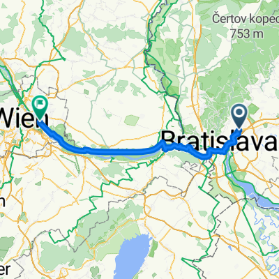
Cez Karpaty na Záhorie
A cycling route starting in Bratislava - Vajnory, Bratislavský kraj, Slovak Republic.
Overview
About this route
Trasa vhodná i pre cestné bicykle, zo začiatku kopcovitá, na Záhorí už rovina. Trasa od Vysokej pri Morave az do Devína vedie náučným chodníkom ( bývalá signálka ), sú tam informačné tabule.
- -:--
- Duration
- 67 km
- Distance
- 517 m
- Ascent
- 540 m
- Descent
- ---
- Avg. speed
- 557 m
- Avg. speed

Route quality
Waytypes & surfaces along the route
Waytypes
Track
21.5 km
(32 %)
Cycleway
13.6 km
(20 %)
Surfaces
Paved
64.5 km
(96 %)
Unpaved
1.7 km
(3 %)
Asphalt
64 km
(96 %)
Gravel
1.6 km
(2 %)
Continue with Bikemap
Use, edit, or download this cycling route
You would like to ride Cez Karpaty na Záhorie or customize it for your own trip? Here is what you can do with this Bikemap route:
Free features
- Save this route as favorite or in collections
- Copy & plan your own version of this route
- Sync your route with Garmin or Wahoo
Premium features
Free trial for 3 days, or one-time payment. More about Bikemap Premium.
- Navigate this route on iOS & Android
- Export a GPX / KML file of this route
- Create your custom printout (try it for free)
- Download this route for offline navigation
Discover more Premium features.
Get Bikemap PremiumFrom our community
Other popular routes starting in Bratislava - Vajnory
 Haimburg_Berg_01
- Distance
- 61.9 km
- Ascent
- 151 m
- Descent
- 150 m
- Location
- Bratislava - Vajnory, Bratislavský kraj, Slovak Republic
 7. Bratislava-Vienna
- Distance
- 72.5 km
- Ascent
- 269 m
- Descent
- 233 m
- Location
- Bratislava - Vajnory, Bratislavský kraj, Slovak Republic
 Long ride from Bratislava to Lednice
- Distance
- 756.5 km
- Ascent
- 2,236 m
- Descent
- 2,207 m
- Location
- Bratislava - Vajnory, Bratislavský kraj, Slovak Republic
 Rača - Rača 2
- Distance
- 21.5 km
- Ascent
- 440 m
- Descent
- 441 m
- Location
- Bratislava - Vajnory, Bratislavský kraj, Slovak Republic
 Vajnorske jazera . Vrakuna . most D4 - Rusovce - Prístavný most- Vlcie hrdlo a spat
- Distance
- 64.1 km
- Ascent
- 49 m
- Descent
- 50 m
- Location
- Bratislava - Vajnory, Bratislavský kraj, Slovak Republic
 Pekná cesta - Biely kríž - Štefánikova mohyla
- Distance
- 46.6 km
- Ascent
- 1,607 m
- Descent
- 1,619 m
- Location
- Bratislava - Vajnory, Bratislavský kraj, Slovak Republic
 Forest ride on Road Bike - Bad Surface
- Distance
- 11.9 km
- Ascent
- 276 m
- Descent
- 275 m
- Location
- Bratislava - Vajnory, Bratislavský kraj, Slovak Republic
 Rock FM Cyklomaraton 2004
- Distance
- 313.5 km
- Ascent
- 1,722 m
- Descent
- 699 m
- Location
- Bratislava - Vajnory, Bratislavský kraj, Slovak Republic
Open it in the app