
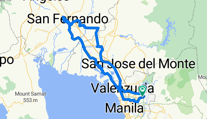
San Fernando Pampanga Ride
A cycling route starting in Quezon City, National Capital Region, Philippines.
Overview
About this route
- -:--
- Duration
- 172.9 km
- Distance
- 110 m
- Ascent
- 104 m
- Descent
- ---
- Avg. speed
- ---
- Avg. speed

Route highlights
Points of interest along the route
Point of interest after 17.1 km
Matigas na Bakery
Point of interest after 47.4 km
Citang's
Point of interest after 83 km
Souq Pampanga (15 Best Restaurants in Pampanga)
Point of interest after 83.5 km
Angeles Fried Chicken
Point of interest after 83.5 km
My Lola Nor's
Point of interest after 83.5 km
Susie's Cuisine (Pampanga's Top 15)
Point of interest after 83.5 km
Aling Lucing's Sisig
Point of interest after 122 km
Carinderia ni Ka Enteng
Continue with Bikemap
Use, edit, or download this cycling route
You would like to ride San Fernando Pampanga Ride or customize it for your own trip? Here is what you can do with this Bikemap route:
Free features
- Save this route as favorite or in collections
- Copy & plan your own version of this route
- Sync your route with Garmin or Wahoo
Premium features
Free trial for 3 days, or one-time payment. More about Bikemap Premium.
- Navigate this route on iOS & Android
- Export a GPX / KML file of this route
- Create your custom printout (try it for free)
- Download this route for offline navigation
Discover more Premium features.
Get Bikemap PremiumFrom our community
Other popular routes starting in Quezon City
 Jog at U.P. Quezon City
- Distance
- 7.6 km
- Ascent
- 59 m
- Descent
- 73 m
- Location
- Quezon City, National Capital Region, Philippines
 My UP Route
- Distance
- 3.4 km
- Ascent
- 21 m
- Descent
- 23 m
- Location
- Quezon City, National Capital Region, Philippines
 Capitol Hills Drive, Quezon City to Capitol Hills Drive, Quezon City
- Distance
- 28 km
- Ascent
- 102 m
- Descent
- 108 m
- Location
- Quezon City, National Capital Region, Philippines
 abs to bgc home
- Distance
- 17 km
- Ascent
- 227 m
- Descent
- 240 m
- Location
- Quezon City, National Capital Region, Philippines
 Diliman loop
- Distance
- 11.1 km
- Ascent
- 59 m
- Descent
- 59 m
- Location
- Quezon City, National Capital Region, Philippines
 Quezon City,Muntinlupa, Bacoor, Las Pinas, Paranaque, Makati, manila, Malabon, Valenzuela, Rizal, San Mateo, QC Loop.
- Distance
- 137.9 km
- Ascent
- 1,020 m
- Descent
- 1,017 m
- Location
- Quezon City, National Capital Region, Philippines
 Route from Commonwealth Avenue 22b, Quezon City
- Distance
- 68.2 km
- Ascent
- 558 m
- Descent
- 674 m
- Location
- Quezon City, National Capital Region, Philippines
 Marikina Loop
- Distance
- 11.4 km
- Ascent
- 76 m
- Descent
- 75 m
- Location
- Quezon City, National Capital Region, Philippines
Open it in the app