
Route des antiquaires CLONED FROM ROUTE 102532
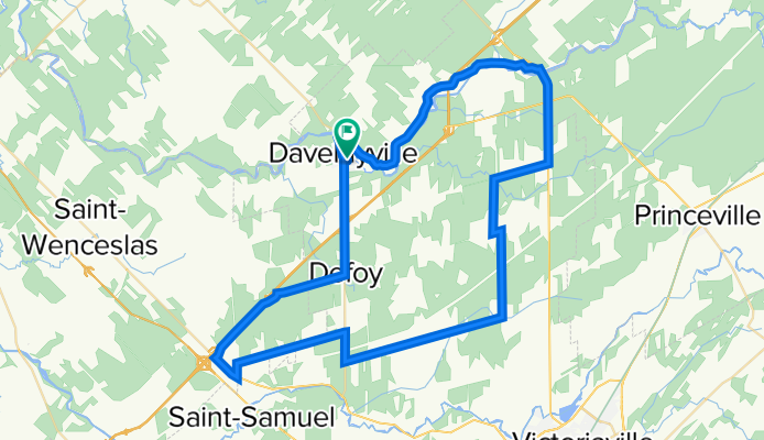
A cycling route starting in Daveluyville, Quebec, Canada.
Overview
About this route
<span style="font-family: Arial;">
<span style="font-size: small;"><span style="font-family: Arial;"><font color="#000000">
<span style="font-size: 12pt; font-family: Arial; mso-fareast-font-family: 'Times New Roman'; mso-ansi-language: FR-CA; mso-fareast-language: FR-CA; mso-bidi-language: AR-SA;"><span style="font-family: Arial;">Roulez sur les routes reliant Victoriaville, Saint-Valère, Daveluyville, Saint-Louis-de-Blandford et Saint-Rosaire. C’est une plaine paisible et agréable située à la porte des Bois-Francs et parsemée d’antiquaires</span></span>
<span style="font-family: Arial;"> </span>
<span style="font-family: Arial;">Départ : Stationnement du Club Sportif de Daveluyville, 1, 9<sup>e</sup> avenue, Daveluyville. </span>
<span style="font-family: Arial;"> </span>
<span style="font-family: Arial;">DIRECTIONS</span>
<span style="font-family: Arial;"> </span>
<span style="font-family: Arial;">Prendre la direction <span style="mso-bidi-font-weight: bold;">nord</span> sur la <span style="mso-bidi-font-weight: bold;">rue Principale</span> vers Maddington et traversez le pont. <span style="mso-bidi-font-weight: bold;"> 1,7 km </span></span>
<span style="font-family: Arial; mso-bidi-font-weight: bold;"> </span>
<span style="font-family: Arial;">Tournez à <span style="mso-bidi-font-weight: bold;">droite</span> sur <span style="mso-bidi-font-weight: bold;">le Rang de la Rivière et roulez jusqu'au Rang Smith de Saint-Louis-de-Blandford. 9,7 km </span></span>
<span style="font-family: Arial; mso-bidi-font-weight: bold;"> </span>
<span style="font-family: Arial;">Traversez le viaduc et roulez jusqu'au village de Saint-Louis-de-Blandford.<span style="mso-bidi-font-weight: bold;"> 4,9 km </span></span>
<span style="font-family: Arial; mso-bidi-font-weight: bold;"> </span>
<span style="font-family: Arial;">Tournez à droite sur la rue Principale et traversez le village. 1,1 km</span>
</font></span></span>
<span style="font-family: Arial;">Empruntez à gauche la Route 162 jusqu'au 4 ième Rang de Saint-Rosaire. 5,6 km</span>
<span style="font-family: Arial;">Attention: utilisez les accotements routiers.</span>
<span style="font-family: Arial;">Tournez à gauche sur le Rang 4. 3,3 km</span>
<span style="font-family: Arial;">Empruntez à votre gauche La Route de l'Église et roulez jusqu'au village. 3 km</span>
<span style="font-family: Arial;">À l'intersection de la rue Principale, tournez à droite et empruntez le Chemin de la Coupe. 0,5 km</span>
<span style="font-family: Arial;">Du Chemin de la Coupe roulez jusqu'au Rang 8. 4,9 km</span>
<span style="font-family: Arial;">À l'intersection tournez à droite sur le Rang 8. 9,4 km</span>
<span style="font-family: Arial;">À la Route 261, tournez à droite jusqu'au Rang des Chênes. 1,7 km</span>
<span style="font-family: Arial;">Tournez à gauche sur le Rang des Chênes jusqu'à la Route des Bouleaux. 6,6 km</span>
<span style="font-family: Arial;">Empruntez à gauche la Route des Bouleaux et ensuite prenez la Route 161 jusqu'au Rang des Cèdres. 2,8 km</span>
<span style="font-family: Arial;">Tournez à droite sur le Rang des Cèdres. 4 km</span>
<span style="font-family: Arial;">Empruntez à droite le Rang des Épinettes juqu'à la route 261. 4 km</span>
<span style="font-family: Arial;">Prenez à gauche sur la route 261 en direction de Daveluyville. 6,5 km</span>
<span style="font-family: Arial;">Attention : circulation automobile rapide.</span>
</span>
Arrivée au Centre Sportif de Daveluyville.
- -:--
- Duration
- 70.7 km
- Distance
- 100 m
- Ascent
- 97 m
- Descent
- ---
- Avg. speed
- ---
- Avg. speed

Route quality
Waytypes & surfaces along the route
Waytypes
Road
47.9 km
(68 %)
Busy road
9.5 km
(13 %)
Surfaces
Paved
9.8 km
(14 %)
Unpaved
1.6 km
(2 %)
Asphalt
6.8 km
(10 %)
Paved (undefined)
3 km
(4 %)
Continue with Bikemap
Use, edit, or download this cycling route
You would like to ride Route des antiquaires CLONED FROM ROUTE 102532 or customize it for your own trip? Here is what you can do with this Bikemap route:
Free features
- Save this route as favorite or in collections
- Copy & plan your own version of this route
- Sync your route with Garmin or Wahoo
Premium features
Free trial for 3 days, or one-time payment. More about Bikemap Premium.
- Navigate this route on iOS & Android
- Export a GPX / KML file of this route
- Create your custom printout (try it for free)
- Download this route for offline navigation
Discover more Premium features.
Get Bikemap PremiumFrom our community
Other popular routes starting in Daveluyville
 1150 Rue Ste-Thérèse, St-Wenceslas à 1150 Rue Ste-Thérèse, St-Wenceslas
- Distance
- 51.1 km
- Ascent
- 140 m
- Descent
- 136 m
- Location
- Daveluyville, Quebec, Canada
 Circuit canneberge
- Distance
- 31.2 km
- Ascent
- 45 m
- Descent
- 46 m
- Location
- Daveluyville, Quebec, Canada
 Cyclo Bois Francs sortie exterieur
- Distance
- 81.8 km
- Ascent
- 127 m
- Descent
- 127 m
- Location
- Daveluyville, Quebec, Canada
 Daveluyville - Rivière Bécancour
- Distance
- 110.6 km
- Ascent
- 175 m
- Descent
- 175 m
- Location
- Daveluyville, Quebec, Canada
 1075 Rue Richard, St-Wenceslas à 1180 Rue Principale, St-Wenceslas
- Distance
- 11.7 km
- Ascent
- 53 m
- Descent
- 49 m
- Location
- Daveluyville, Quebec, Canada
 Route des antiquaires CLONED FROM ROUTE 102532
- Distance
- 70.7 km
- Ascent
- 100 m
- Descent
- 97 m
- Location
- Daveluyville, Quebec, Canada
 Daveluyville Cycling
- Distance
- 13.9 km
- Ascent
- 40 m
- Descent
- 54 m
- Location
- Daveluyville, Quebec, Canada
 carré des anges
- Distance
- 61.7 km
- Ascent
- 103 m
- Descent
- 102 m
- Location
- Daveluyville, Quebec, Canada
Open it in the app