
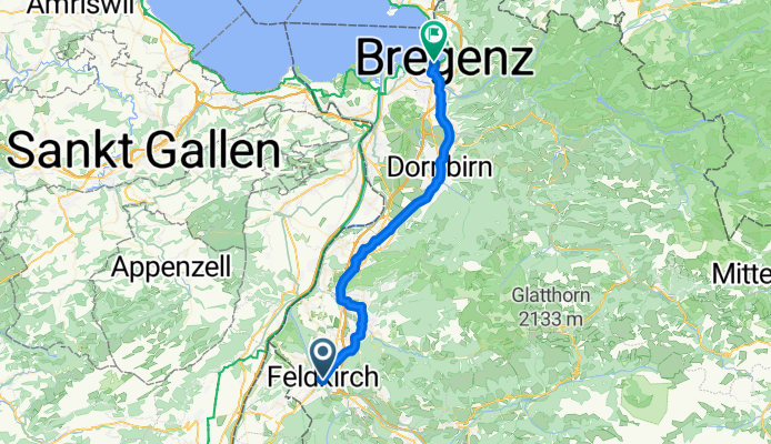
Feldkirch - Hohenems - Bregenz
A cycling route starting in Feldkirch, Vorarlberg, Austria.
Overview
About this route
- -:--
- Duration
- 42.3 km
- Distance
- 112 m
- Ascent
- 179 m
- Descent
- ---
- Avg. speed
- ---
- Avg. speed

Route quality
Waytypes & surfaces along the route
Waytypes
Quiet road
16.9 km
(40 %)
Cycleway
7.4 km
(17 %)
Surfaces
Paved
39.8 km
(94 %)
Unpaved
2 km
(5 %)
Asphalt
39.5 km
(94 %)
Loose gravel
0.9 km
(2 %)
Continue with Bikemap
Use, edit, or download this cycling route
You would like to ride Feldkirch - Hohenems - Bregenz or customize it for your own trip? Here is what you can do with this Bikemap route:
Free features
- Save this route as favorite or in collections
- Copy & plan your own version of this route
- Sync your route with Garmin or Wahoo
Premium features
Free trial for 3 days, or one-time payment. More about Bikemap Premium.
- Navigate this route on iOS & Android
- Export a GPX / KML file of this route
- Create your custom printout (try it for free)
- Download this route for offline navigation
Discover more Premium features.
Get Bikemap PremiumFrom our community
Other popular routes starting in Feldkirch
 SoTo 2018/6: Feldkirch - Einsiedeln
- Distance
- 113.8 km
- Ascent
- 764 m
- Descent
- 322 m
- Location
- Feldkirch, Vorarlberg, Austria
 Bodensee Neusiedlersee
- Distance
- 982.6 km
- Ascent
- 307 m
- Descent
- 637 m
- Location
- Feldkirch, Vorarlberg, Austria
 Stella 2
- Distance
- 6.2 km
- Ascent
- 23 m
- Descent
- 845 m
- Location
- Feldkirch, Vorarlberg, Austria
 Von Tisis durchs Motafon und Verwall zum Spullersee
- Distance
- 103.6 km
- Ascent
- 2,661 m
- Descent
- 1,448 m
- Location
- Feldkirch, Vorarlberg, Austria
 Feldkirch - Uebersaxen - Duens - Satteins - Feldkirch
- Distance
- 35 km
- Ascent
- 674 m
- Descent
- 674 m
- Location
- Feldkirch, Vorarlberg, Austria
 Feldkirch railway station to Franstanz hotel (Austria)
- Distance
- 6.3 km
- Ascent
- 55 m
- Descent
- 49 m
- Location
- Feldkirch, Vorarlberg, Austria
 Über Paula Hütte, Gerawald wieder nach Tisis
- Distance
- 20.1 km
- Ascent
- 995 m
- Descent
- 998 m
- Location
- Feldkirch, Vorarlberg, Austria
 Feldkirch - Pragelpass
- Distance
- 98.1 km
- Ascent
- 2,425 m
- Descent
- 2,036 m
- Location
- Feldkirch, Vorarlberg, Austria
Open it in the app