

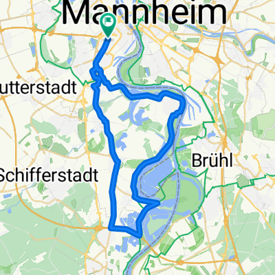
Tour de France mini
A cycling route starting in Ludwigshafen am Rhein, Rhineland-Palatinate, Germany.
Overview
About this route
- -:--
- Duration
- 81.7 km
- Distance
- 94 m
- Ascent
- 73 m
- Descent
- ---
- Avg. speed
- ---
- Avg. speed

Route quality
Waytypes & surfaces along the route
Waytypes
Track
28.1 km
(34 %)
Path
25.4 km
(31 %)
Surfaces
Paved
76.5 km
(94 %)
Unpaved
1.3 km
(2 %)
Asphalt
67.3 km
(82 %)
Paving stones
5.7 km
(7 %)
Continue with Bikemap
Use, edit, or download this cycling route
You would like to ride Tour de France mini or customize it for your own trip? Here is what you can do with this Bikemap route:
Free features
- Save this route as favorite or in collections
- Copy & plan your own version of this route
- Sync your route with Garmin or Wahoo
Premium features
Free trial for 3 days, or one-time payment. More about Bikemap Premium.
- Navigate this route on iOS & Android
- Export a GPX / KML file of this route
- Create your custom printout (try it for free)
- Download this route for offline navigation
Discover more Premium features.
Get Bikemap PremiumFrom our community
Other popular routes starting in Ludwigshafen am Rhein
 BASF Radtour 2011
- Distance
- 159.1 km
- Ascent
- 667 m
- Descent
- 668 m
- Location
- Ludwigshafen am Rhein, Rhineland-Palatinate, Germany
 Von Mannheim nach Eberbach
- Distance
- 56.5 km
- Ascent
- 211 m
- Descent
- 175 m
- Location
- Ludwigshafen am Rhein, Rhineland-Palatinate, Germany
 43_Ludwigshafen – Friedelsheim – Bad Dürkheim
- Distance
- 24.7 km
- Ascent
- 62 m
- Descent
- 18 m
- Location
- Ludwigshafen am Rhein, Rhineland-Palatinate, Germany
 50 ziger Runde
- Distance
- 50.3 km
- Ascent
- 57 m
- Descent
- 57 m
- Location
- Ludwigshafen am Rhein, Rhineland-Palatinate, Germany
 LU-Kalmit-LU
- Distance
- 97.5 km
- Ascent
- 688 m
- Descent
- 694 m
- Location
- Ludwigshafen am Rhein, Rhineland-Palatinate, Germany
 Rheinradweg Sandbachroute Schwarzwaldhochstraße
- Distance
- 157.2 km
- Ascent
- 829 m
- Descent
- 79 m
- Location
- Ludwigshafen am Rhein, Rhineland-Palatinate, Germany
 Ludwigshafener Trainingsrunde
- Distance
- 41.2 km
- Ascent
- 63 m
- Descent
- 64 m
- Location
- Ludwigshafen am Rhein, Rhineland-Palatinate, Germany
 MA - Speyer
- Distance
- 55.5 km
- Ascent
- 71 m
- Descent
- 71 m
- Location
- Ludwigshafen am Rhein, Rhineland-Palatinate, Germany
Open it in the app