
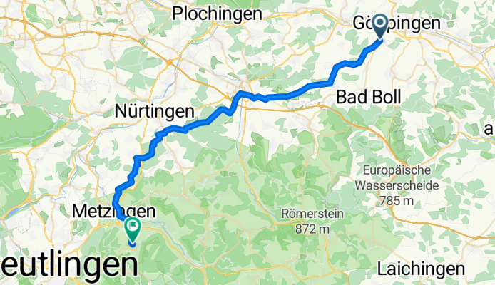
Karlsbader Straße 24, Göppingen nach Geranienweg 11, Metzingen
A cycling route starting in Göppingen, Baden-Württemberg, Germany.
Overview
About this route
- 2 h 43 min
- Duration
- 43.2 km
- Distance
- 507 m
- Ascent
- 436 m
- Descent
- 16 km/h
- Avg. speed
- ---
- Avg. speed

Route quality
Waytypes & surfaces along the route
Waytypes
Track
16.2 km
(37 %)
Quiet road
12.1 km
(28 %)
Surfaces
Paved
28.9 km
(67 %)
Unpaved
5 km
(11 %)
Asphalt
20.4 km
(47 %)
Paved (undefined)
7.6 km
(18 %)
Continue with Bikemap
Use, edit, or download this cycling route
You would like to ride Karlsbader Straße 24, Göppingen nach Geranienweg 11, Metzingen or customize it for your own trip? Here is what you can do with this Bikemap route:
Free features
- Save this route as favorite or in collections
- Copy & plan your own version of this route
- Sync your route with Garmin or Wahoo
Premium features
Free trial for 3 days, or one-time payment. More about Bikemap Premium.
- Navigate this route on iOS & Android
- Export a GPX / KML file of this route
- Create your custom printout (try it for free)
- Download this route for offline navigation
Discover more Premium features.
Get Bikemap PremiumFrom our community
Other popular routes starting in Göppingen
 Göppingen - Drei Kaiser Berge
- Distance
- 31.8 km
- Ascent
- 770 m
- Descent
- 766 m
- Location
- Göppingen, Baden-Württemberg, Germany
 Training
- Distance
- 50.1 km
- Ascent
- 1,393 m
- Descent
- 1,504 m
- Location
- Göppingen, Baden-Württemberg, Germany
 Falkenstraße 19, Göppingen nach Eybstraße 16/2, Geislingen an der Steige
- Distance
- 17 km
- Ascent
- 45 m
- Descent
- 0 m
- Location
- Göppingen, Baden-Württemberg, Germany
 Abendrunde MTB
- Distance
- 23.6 km
- Ascent
- 191 m
- Descent
- 191 m
- Location
- Göppingen, Baden-Württemberg, Germany
 Göppingen - Weilheim - Schopfloch - Donnstetten - Wiesensteig - Schlat - Göppingen
- Distance
- 73 km
- Ascent
- 788 m
- Descent
- 788 m
- Location
- Göppingen, Baden-Württemberg, Germany
 Feierabendtour Rennrad
- Distance
- 41.8 km
- Ascent
- 676 m
- Descent
- 654 m
- Location
- Göppingen, Baden-Württemberg, Germany
 Göppingen - Gingen - Bad Ditzenbach - Fuchseck
- Distance
- 48.9 km
- Ascent
- 747 m
- Descent
- 747 m
- Location
- Göppingen, Baden-Württemberg, Germany
 kleine Göppingen Hügeltour
- Distance
- 44.5 km
- Ascent
- 567 m
- Descent
- 487 m
- Location
- Göppingen, Baden-Württemberg, Germany
Open it in the app