
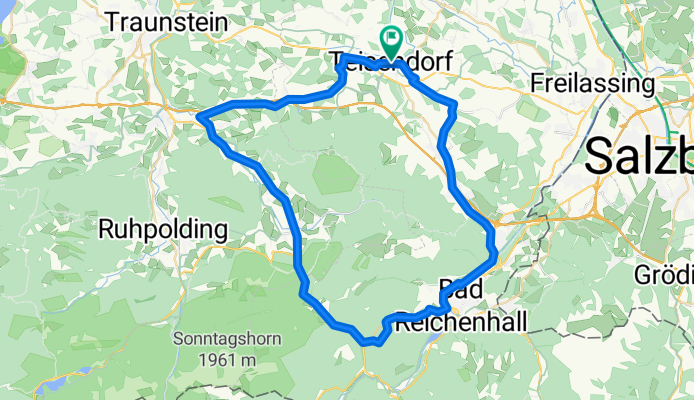
Rund um den Staufen und Zwiesel
A cycling route starting in Teisendorf, Bavaria, Germany.
Overview
About this route
Ab Thumsee habe ich einen Wald- und Höhenweg genommen und mußte teils auf unbefestigtem Weg fahren (vorsichtig), teils das Rad tragen. War den Abstecher (für mich) wert.
- -:--
- Duration
- 57.7 km
- Distance
- 817 m
- Ascent
- 689 m
- Descent
- ---
- Avg. speed
- 692 m
- Avg. speed

Route quality
Waytypes & surfaces along the route
Waytypes
Busy road
24 km
(42 %)
Path
13.9 km
(24 %)
Surfaces
Paved
47.5 km
(82 %)
Unpaved
6.4 km
(11 %)
Asphalt
46.4 km
(80 %)
Gravel
3.4 km
(6 %)
Continue with Bikemap
Use, edit, or download this cycling route
You would like to ride Rund um den Staufen und Zwiesel or customize it for your own trip? Here is what you can do with this Bikemap route:
Free features
- Save this route as favorite or in collections
- Copy & plan your own version of this route
- Sync your route with Garmin or Wahoo
Premium features
Free trial for 3 days, or one-time payment. More about Bikemap Premium.
- Navigate this route on iOS & Android
- Export a GPX / KML file of this route
- Create your custom printout (try it for free)
- Download this route for offline navigation
Discover more Premium features.
Get Bikemap PremiumFrom our community
Other popular routes starting in Teisendorf
 Traunsteinrunde
- Distance
- 38.9 km
- Ascent
- 409 m
- Descent
- 409 m
- Location
- Teisendorf, Bavaria, Germany
 Variante um den Waginger und Tachinger See
- Distance
- 64.4 km
- Ascent
- 591 m
- Descent
- 579 m
- Location
- Teisendorf, Bavaria, Germany
 Abtsdorfer See
- Distance
- 44.2 km
- Ascent
- 324 m
- Descent
- 327 m
- Location
- Teisendorf, Bavaria, Germany
 2015_Teisendorf_Freilassing
- Distance
- 44.1 km
- Ascent
- 100 m
- Descent
- 181 m
- Location
- Teisendorf, Bavaria, Germany
 2016_2_Königssee - Bodensee (Teisendorf - Aschau)
- Distance
- 72 km
- Ascent
- 674 m
- Descent
- 574 m
- Location
- Teisendorf, Bavaria, Germany
 Alpenvorland_Tour29_Waginger See
- Distance
- 35.8 km
- Ascent
- 353 m
- Descent
- 353 m
- Location
- Teisendorf, Bavaria, Germany
 2012 Teisendorf-Schönau/Königssee
- Distance
- 48.8 km
- Ascent
- 446 m
- Descent
- 335 m
- Location
- Teisendorf, Bavaria, Germany
 Stoißeralm
- Distance
- 26.3 km
- Ascent
- 1,098 m
- Descent
- 993 m
- Location
- Teisendorf, Bavaria, Germany
Open it in the app