
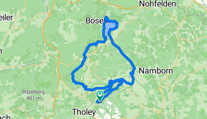
Von Tholey zum Bostalsee und zurück
A cycling route starting in Tholey, Saarland, Germany.
Overview
About this route
- -:--
- Duration
- 36.9 km
- Distance
- 408 m
- Ascent
- 409 m
- Descent
- ---
- Avg. speed
- ---
- Avg. speed
Route quality
Waytypes & surfaces along the route
Waytypes
Track
10.1 km
(27 %)
Path
10 km
(27 %)
Surfaces
Paved
29.5 km
(80 %)
Unpaved
6.7 km
(18 %)
Asphalt
21.8 km
(59 %)
Paved (undefined)
7.3 km
(20 %)
Route highlights
Points of interest along the route
Photo after 5.9 km
Weißstörche bei der Göckelmühle
Photo after 5.9 km
Weißstörche bei der Göckelmühle
Photo after 13.4 km
Blick auf Center Parcs - Ferienhäuser
Photo after 13.9 km
Bostalsee
Photo after 14.2 km
Photo after 15.2 km
Photo after 15.6 km
Photo after 17.4 km
Photo after 25.7 km
Hofgut Imsbach
Photo after 25.7 km
Hofgut Imsbach
Photo after 25.7 km
Hofgut Imsbach
Photo after 25.8 km
Photo after 26.5 km
Johann Adams Mühle
Photo after 26.5 km
Johann Adams Mühle
Continue with Bikemap
Use, edit, or download this cycling route
You would like to ride Von Tholey zum Bostalsee und zurück or customize it for your own trip? Here is what you can do with this Bikemap route:
Free features
- Save this route as favorite or in collections
- Copy & plan your own version of this route
- Sync your route with Garmin or Wahoo
Premium features
Free trial for 3 days, or one-time payment. More about Bikemap Premium.
- Navigate this route on iOS & Android
- Export a GPX / KML file of this route
- Create your custom printout (try it for free)
- Download this route for offline navigation
Discover more Premium features.
Get Bikemap PremiumFrom our community
Other popular routes starting in Tholey
 Jahann-Adams-Mühle-Theley-Oberthal-Bostalsee-Selbach Nahequelle-Theley
- Distance
- 29.4 km
- Ascent
- 506 m
- Descent
- 509 m
- Location
- Tholey, Saarland, Germany
 Drei-Burgen-Fahrt 2010 - RTF des RV Schaumberg Theley e.V. - 155 km Strecke
- Distance
- 149.9 km
- Ascent
- 1,996 m
- Descent
- 1,986 m
- Location
- Tholey, Saarland, Germany
 Drei-Burgen-Fahrt 2013 - RTF des RV Schaumberg Theley e.V. - 118 km Strecke
- Distance
- 120.5 km
- Ascent
- 1,703 m
- Descent
- 1,733 m
- Location
- Tholey, Saarland, Germany
 Drei-Burgen-Fahrt 2013 - RTF des RV Schaumberg Theley e.V. - 71 km Strecke
- Distance
- 73 km
- Ascent
- 878 m
- Descent
- 890 m
- Location
- Tholey, Saarland, Germany
 3-Seen-Tour
- Distance
- 59.6 km
- Ascent
- 851 m
- Descent
- 852 m
- Location
- Tholey, Saarland, Germany
 Tafeltour Offizierspfad Imsbach
- Distance
- 11.1 km
- Ascent
- 252 m
- Descent
- 251 m
- Location
- Tholey, Saarland, Germany
 3-Seen-Tour
- Distance
- 59.6 km
- Ascent
- 827 m
- Descent
- 840 m
- Location
- Tholey, Saarland, Germany
 St.Wendeler Land
- Distance
- 51.1 km
- Ascent
- 1,816 m
- Descent
- 1,817 m
- Location
- Tholey, Saarland, Germany
Open it in the app