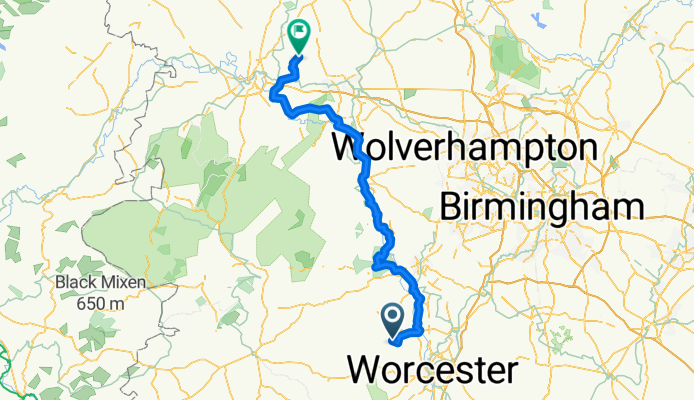
Lejog Day 8: Wichenford to High Ercall
A cycling route starting in Cotheridge, England, United Kingdom.
Overview
About this route
- -:--
- Duration
- 98.2 km
- Distance
- 561 m
- Ascent
- 572 m
- Descent
- ---
- Avg. speed
- ---
- Avg. speed
Route quality
Waytypes & surfaces along the route
Waytypes
Undefined
98.2 km
(100 %)
Surfaces
Undefined
98.2 km
(100 %)
Route highlights
Points of interest along the route
Drinking water after 16.4 km
Accommodation after 46.5 km
The Bull's Head Inn 1 Cobblers Row Bridgnorth, Shropshire WV16 6BA United Kingdom Book online or CALL 0203 027 867
Accommodation after 50.1 km
The Swan Inn Knowle Sands, WV16 5JL Bridgnorth
Accommodation after 51.2 km
Severn Arms 3 Underhill St, Bridgnorth, England - Shropshire WV16 4BB 01746 764616 ‎ thesevernarms.co.uk
Accommodation after 51.3 km
Stoneway Guest House, Stoneway Steps, Bridgnorth, Shropshire WV16 4BD 01746 764063
Accommodation after 51.9 km
Croft The 10-11 St. Marys Street, Bridgnorth, Shropshire WV16 4DW 01746 762416 ‎ crofthotelbridgnorth.co.uk
Drinking water after 52 km
Accommodation after 74.2 km
Church Farm Guest House Wrockwardine Village, Telford, Shropshire TF6 5DG 01952 251927 ‎ churchfarm-shropshire.co.uk
Accommodation after 83.3 km
Wroxeter Hotel Wroxeter, Nr. Shrewsbury, Shropshire SY5 6PH 01743 761256 ‎ thewroxeterhotel.co.uk
Accommodation after 85.8 km
Brompton Farmhouse Bed and Breakfast‎ R Cross Houses Shrewsbury, Shropshire SY5 6LE 01743 761 629 bromptonfarmhouse.co.uk‎
Accommodation after 86.7 km
The Mytton & Mermaid Atcham, Shrewsbury, Shropshire SY5 6QG 01743 761220 ‎ myttonandmermaid.co.uk
Drinking water after 87.4 km
Stan Jones
Drinking water after 87.5 km
Hawk Factory
Accommodation after 93.8 km
The Grove Inn Bluebell Grange, Allscott, TELFORD, Shropshire TF6 5EN 01952 740814 ‎
Accommodation after 98 km
The Mill House High Ercall, Telford TF6 6BE 01952 770 394 ercallmill.co.uk‎
Continue with Bikemap
Use, edit, or download this cycling route
You would like to ride Lejog Day 8: Wichenford to High Ercall or customize it for your own trip? Here is what you can do with this Bikemap route:
Free features
- Save this route as favorite or in collections
- Copy & plan your own version of this route
- Sync your route with Garmin or Wahoo
Premium features
Free trial for 3 days, or one-time payment. More about Bikemap Premium.
- Navigate this route on iOS & Android
- Export a GPX / KML file of this route
- Create your custom printout (try it for free)
- Download this route for offline navigation
Discover more Premium features.
Get Bikemap PremiumFrom our community
Other popular routes starting in Cotheridge
- LEJOG Day 5
- Distance
- 93.8 km
- Ascent
- 765 m
- Descent
- 723 m
- Location
- Cotheridge, England, United Kingdom
- Lejog Day 8: Wichenford to High Ercall
- Distance
- 98.2 km
- Ascent
- 557 m
- Descent
- 567 m
- Location
- Cotheridge, England, United Kingdom
- wichenford to charlbury
- Distance
- 106.9 km
- Ascent
- 607 m
- Descent
- 604 m
- Location
- Cotheridge, England, United Kingdom
- JOGLE Day 16
- Distance
- 66 km
- Ascent
- 542 m
- Descent
- 396 m
- Location
- Cotheridge, England, United Kingdom
- Slow ride in Worcester
- Distance
- 19.7 km
- Ascent
- 351 m
- Descent
- 351 m
- Location
- Cotheridge, England, United Kingdom
- 35km route
- Distance
- 36.2 km
- Ascent
- 298 m
- Descent
- 301 m
- Location
- Cotheridge, England, United Kingdom
- Stourport
- Distance
- 48.9 km
- Ascent
- 235 m
- Descent
- 258 m
- Location
- Cotheridge, England, United Kingdom
- 35km route
- Distance
- 35.4 km
- Ascent
- 311 m
- Descent
- 309 m
- Location
- Cotheridge, England, United Kingdom