
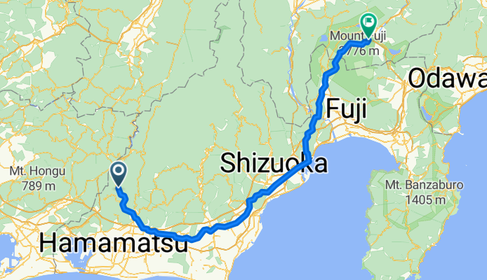
976-1, Kuma, Tenryu, Hamamatsu to 4959-2, Kamiyoshida, Fujiyoshida
A cycling route starting in Hamakita, Shizuoka, Japan.
Overview
About this route
- 9 h 38 min
- Duration
- 172.2 km
- Distance
- 3,181 m
- Ascent
- 2,538 m
- Descent
- 17.9 km/h
- Avg. speed
- ---
- Avg. speed
Route quality
Waytypes & surfaces along the route
Waytypes
Quiet road
56.3 km
(33 %)
Busy road
49.5 km
(29 %)
Surfaces
Paved
32.8 km
(19 %)
Unpaved
0.3 km
(<1 %)
Paved (undefined)
23.5 km
(14 %)
Asphalt
9.3 km
(5 %)
Continue with Bikemap
Use, edit, or download this cycling route
You would like to ride 976-1, Kuma, Tenryu, Hamamatsu to 4959-2, Kamiyoshida, Fujiyoshida or customize it for your own trip? Here is what you can do with this Bikemap route:
Free features
- Save this route as favorite or in collections
- Copy & plan your own version of this route
- Sync your route with Garmin or Wahoo
Premium features
Free trial for 3 days, or one-time payment. More about Bikemap Premium.
- Navigate this route on iOS & Android
- Export a GPX / KML file of this route
- Create your custom printout (try it for free)
- Download this route for offline navigation
Discover more Premium features.
Get Bikemap PremiumFrom our community
Other popular routes starting in Hamakita
 浜北-福田漁港
- Distance
- 68.3 km
- Ascent
- 79 m
- Descent
- 79 m
- Location
- Hamakita, Shizuoka, Japan
 浜北-光明山遺跡
- Distance
- 54.5 km
- Ascent
- 773 m
- Descent
- 770 m
- Location
- Hamakita, Shizuoka, Japan
 浜北-秋葉山(秋葉神社)
- Distance
- 67.9 km
- Ascent
- 970 m
- Descent
- 967 m
- Location
- Hamakita, Shizuoka, Japan
 浜北-桜咲く学校
- Distance
- 60.1 km
- Ascent
- 482 m
- Descent
- 480 m
- Location
- Hamakita, Shizuoka, Japan
 浜北-天竜川河口
- Distance
- 49.5 km
- Ascent
- 133 m
- Descent
- 130 m
- Location
- Hamakita, Shizuoka, Japan
 浜北-油山寺、可睡斎、法多山
- Distance
- 55.6 km
- Ascent
- 340 m
- Descent
- 341 m
- Location
- Hamakita, Shizuoka, Japan
 浜北-三河湖(羽布ダム)
- Distance
- 159.7 km
- Ascent
- 1,322 m
- Descent
- 1,322 m
- Location
- Hamakita, Shizuoka, Japan
 浜北-浜北森林公園
- Distance
- 17.7 km
- Ascent
- 178 m
- Descent
- 175 m
- Location
- Hamakita, Shizuoka, Japan
Open it in the app