
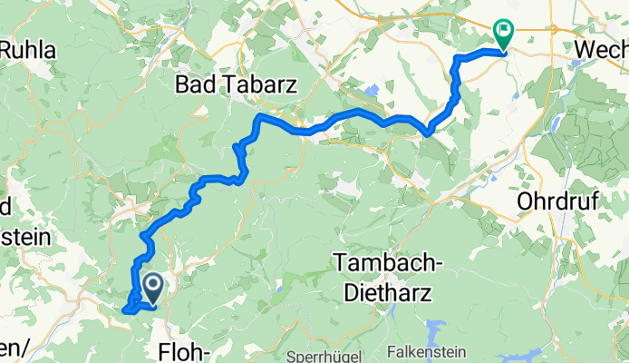
Mommelstein-Radwanderweg, Floh-Seligenthal nach Kellerplatz 3, Emleben
A cycling route starting in Pappenheim, Free State of Thuringia, Germany.
Overview
About this route
- 4 h 22 min
- Duration
- 36.9 km
- Distance
- 1,680 m
- Ascent
- 1,846 m
- Descent
- 8.4 km/h
- Avg. speed
- ---
- Avg. speed
Route quality
Waytypes & surfaces along the route
Waytypes
Track
27.3 km
(74 %)
Quiet road
2.7 km
(7 %)
Surfaces
Paved
11.3 km
(31 %)
Unpaved
23.1 km
(63 %)
Gravel
13.6 km
(37 %)
Asphalt
11 km
(30 %)
Continue with Bikemap
Use, edit, or download this cycling route
You would like to ride Mommelstein-Radwanderweg, Floh-Seligenthal nach Kellerplatz 3, Emleben or customize it for your own trip? Here is what you can do with this Bikemap route:
Free features
- Save this route as favorite or in collections
- Copy & plan your own version of this route
- Sync your route with Garmin or Wahoo
Premium features
Free trial for 3 days, or one-time payment. More about Bikemap Premium.
- Navigate this route on iOS & Android
- Export a GPX / KML file of this route
- Create your custom printout (try it for free)
- Download this route for offline navigation
Discover more Premium features.
Get Bikemap PremiumFrom our community
Other popular routes starting in Pappenheim
 GROßER INSELSBERG, por Kleinschmalkalden
- Distance
- 11 km
- Ascent
- 542 m
- Descent
- 111 m
- Location
- Pappenheim, Free State of Thuringia, Germany
 Ebertswiesen- Mommelstein-Tour
- Distance
- 27.4 km
- Ascent
- 587 m
- Descent
- 638 m
- Location
- Pappenheim, Free State of Thuringia, Germany
 MOMMELSTEIN BREITUNG
- Distance
- 28.6 km
- Ascent
- 53 m
- Descent
- 504 m
- Location
- Pappenheim, Free State of Thuringia, Germany
 03-Ebertswiese-Schneekopf
- Distance
- 31.9 km
- Ascent
- 498 m
- Descent
- 292 m
- Location
- Pappenheim, Free State of Thuringia, Germany
 Rennsteig Inselsberg
- Distance
- 14.7 km
- Ascent
- 531 m
- Descent
- 359 m
- Location
- Pappenheim, Free State of Thuringia, Germany
 Quellenweg
- Distance
- 8.1 km
- Ascent
- 219 m
- Descent
- 210 m
- Location
- Pappenheim, Free State of Thuringia, Germany
 Ebertswiese1
- Distance
- 7.4 km
- Ascent
- 415 m
- Descent
- 248 m
- Location
- Pappenheim, Free State of Thuringia, Germany
 EWiese-TDietharz-Cwinke-ARN
- Distance
- 46 km
- Ascent
- 562 m
- Descent
- 1,016 m
- Location
- Pappenheim, Free State of Thuringia, Germany
Open it in the app