

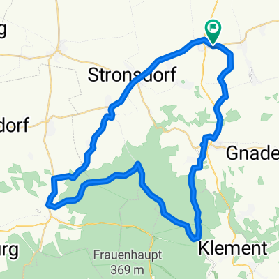
Hochstraße-Kleinkadolz
A cycling route starting in Unterstinkenbrunn, Lower Austria, Austria.
Overview
About this route
- -:--
- Duration
- 37.8 km
- Distance
- 296 m
- Ascent
- 296 m
- Descent
- ---
- Avg. speed
- ---
- Avg. speed
Route quality
Waytypes & surfaces along the route
Waytypes
Track
22.4 km
(59 %)
Busy road
9.9 km
(26 %)
Surfaces
Paved
8.2 km
(22 %)
Unpaved
19.2 km
(51 %)
Gravel
16.7 km
(44 %)
Asphalt
7.1 km
(19 %)
Continue with Bikemap
Use, edit, or download this cycling route
You would like to ride Hochstraße-Kleinkadolz or customize it for your own trip? Here is what you can do with this Bikemap route:
Free features
- Save this route as favorite or in collections
- Copy & plan your own version of this route
- Sync your route with Garmin or Wahoo
Premium features
Free trial for 3 days, or one-time payment. More about Bikemap Premium.
- Navigate this route on iOS & Android
- Export a GPX / KML file of this route
- Create your custom printout (try it for free)
- Download this route for offline navigation
Discover more Premium features.
Get Bikemap PremiumFrom our community
Other popular routes starting in Unterstinkenbrunn
 Eiserne Reblaus
- Distance
- 17.8 km
- Ascent
- 57 m
- Descent
- 57 m
- Location
- Unterstinkenbrunn, Lower Austria, Austria
 Eiserne Reblaus - Bike (1 Runde)
- Distance
- 18.1 km
- Ascent
- 63 m
- Descent
- 58 m
- Location
- Unterstinkenbrunn, Lower Austria, Austria
 unterstinkenbrunn
- Distance
- 88.6 km
- Ascent
- 572 m
- Descent
- 572 m
- Location
- Unterstinkenbrunn, Lower Austria, Austria
 Badsiedlung 24, Unterstinkenbrunn nach Badsiedlung 26, Unterstinkenbrunn
- Distance
- 31.6 km
- Ascent
- 376 m
- Descent
- 376 m
- Location
- Unterstinkenbrunn, Lower Austria, Austria
 Hochstraße-Kleinkadolz
- Distance
- 37.8 km
- Ascent
- 296 m
- Descent
- 296 m
- Location
- Unterstinkenbrunn, Lower Austria, Austria
 Unterstinkenbrunn Gaubitsch
- Distance
- 31.3 km
- Ascent
- 550 m
- Descent
- 550 m
- Location
- Unterstinkenbrunn, Lower Austria, Austria
 Radrunde "Eiserne Reblaus"
- Distance
- 18.5 km
- Ascent
- 56 m
- Descent
- 56 m
- Location
- Unterstinkenbrunn, Lower Austria, Austria
 Freiheit von Stronsdorf
- Distance
- 39.6 km
- Ascent
- 432 m
- Descent
- 432 m
- Location
- Unterstinkenbrunn, Lower Austria, Austria
Open it in the app