

Die Oker Braunschweig Nord
A cycling route starting in Braunschweig, Lower Saxony, Germany.
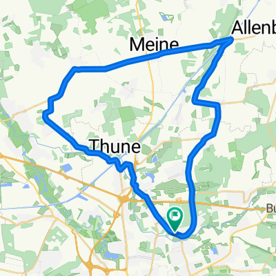
Overview
About this route
Die Wasserschildkröte ist nicht am Amazonas, sondern am Oker Altarm kurz vor Volkse fotografiert. Dem Feldweg kann mann noch ca. 200 m folgen und trift auf einen Betonsockel. Von da aus, mit etwas Glück, können Schildkröten beobachtet werden.
An die Oker kommt man relativ selten, aber dort, wo es möglich ist, findet man traumhaft schöne Motive.
- -:--
- Duration
- 91.9 km
- Distance
- 67 m
- Ascent
- 70 m
- Descent
- ---
- Avg. speed
- ---
- Avg. speed

Route photos


Route quality
Waytypes & surfaces along the route
Waytypes
Track
18.7 km
(20 %)
Quiet road
16.6 km
(18 %)
Surfaces
Paved
53.3 km
(58 %)
Unpaved
15.1 km
(16 %)
Asphalt
49.7 km
(54 %)
Gravel
5.7 km
(6 %)
Continue with Bikemap
Use, edit, or download this cycling route
You would like to ride Die Oker Braunschweig Nord or customize it for your own trip? Here is what you can do with this Bikemap route:
Free features
- Save this route as favorite or in collections
- Copy & plan your own version of this route
- Sync your route with Garmin or Wahoo
Premium features
Free trial for 3 days, or one-time payment. More about Bikemap Premium.
- Navigate this route on iOS & Android
- Export a GPX / KML file of this route
- Create your custom printout (try it for free)
- Download this route for offline navigation
Discover more Premium features.
Get Bikemap PremiumFrom our community
Other popular routes starting in Braunschweig
 Cyclions-Harztour
- Distance
- 150.9 km
- Ascent
- 1,113 m
- Descent
- 1,099 m
- Location
- Braunschweig, Lower Saxony, Germany
 8. Familienradtour -Wolfenbüttel-
- Distance
- 60.1 km
- Ascent
- 209 m
- Descent
- 209 m
- Location
- Braunschweig, Lower Saxony, Germany
 Braunschweig-Fallersleben
- Distance
- 27 km
- Ascent
- 73 m
- Descent
- 73 m
- Location
- Braunschweig, Lower Saxony, Germany
 Sickte-Elm-Schöppenstedt-Asse-Salzdahlum
- Distance
- 72.1 km
- Ascent
- 488 m
- Descent
- 484 m
- Location
- Braunschweig, Lower Saxony, Germany
 BS-GS-Clausthal-Oker-Schladen-Wf-BS
- Distance
- 148.8 km
- Ascent
- 983 m
- Descent
- 979 m
- Location
- Braunschweig, Lower Saxony, Germany
 Morgensternteich
- Distance
- 86.5 km
- Ascent
- 330 m
- Descent
- 332 m
- Location
- Braunschweig, Lower Saxony, Germany
 BS-Nord (sehr kurz)
- Distance
- 34.9 km
- Ascent
- 62 m
- Descent
- 49 m
- Location
- Braunschweig, Lower Saxony, Germany
 Kennelbad ==> Wolfenbüttel
- Distance
- 10.1 km
- Ascent
- 25 m
- Descent
- 7 m
- Location
- Braunschweig, Lower Saxony, Germany
Open it in the app