

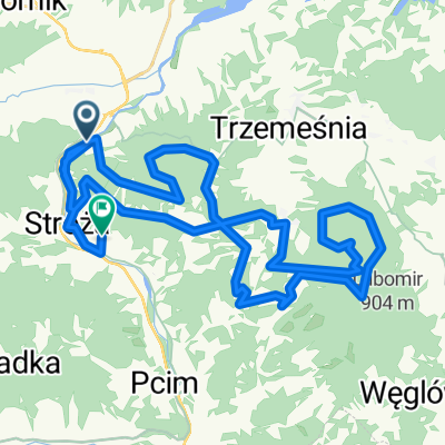
Myślenice-osieczany-Droginia-Brzezowa-Kornatka-Dobczyce-Brzaczowice-Borzęta-Myślenice
A cycling route starting in Myślenice, Lesser Poland Voivodeship, Poland.
Overview
About this route
Trasa wokół zalewu Dobczyckiego prowadząca drogami utwardzanymi. Rekreacyjno - widokowa z mozliwościa zwiedzenia dobczyckiego zamku i skansenu
- -:--
- Duration
- 32.8 km
- Distance
- 493 m
- Ascent
- 480 m
- Descent
- ---
- Avg. speed
- ---
- Avg. speed
Route quality
Waytypes & surfaces along the route
Waytypes
Road
16.1 km
(49 %)
Busy road
5.3 km
(16 %)
Surfaces
Paved
19.9 km
(61 %)
Unpaved
2.1 km
(6 %)
Asphalt
19.3 km
(59 %)
Unpaved (undefined)
1.2 km
(4 %)
Continue with Bikemap
Use, edit, or download this cycling route
You would like to ride Myślenice-osieczany-Droginia-Brzezowa-Kornatka-Dobczyce-Brzaczowice-Borzęta-Myślenice or customize it for your own trip? Here is what you can do with this Bikemap route:
Free features
- Save this route as favorite or in collections
- Copy & plan your own version of this route
- Sync your route with Garmin or Wahoo
Premium features
Free trial for 3 days, or one-time payment. More about Bikemap Premium.
- Navigate this route on iOS & Android
- Export a GPX / KML file of this route
- Create your custom printout (try it for free)
- Download this route for offline navigation
Discover more Premium features.
Get Bikemap PremiumFrom our community
Other popular routes starting in Myślenice
 MTB 2016 Myślenice w błocie
- Distance
- 27.1 km
- Ascent
- 1,030 m
- Descent
- 1,032 m
- Location
- Myślenice, Lesser Poland Voivodeship, Poland
 Myslenice
- Distance
- 46.2 km
- Ascent
- 1,429 m
- Descent
- 1,347 m
- Location
- Myślenice, Lesser Poland Voivodeship, Poland
 Beskid Makowski, Myślenice-Lubomir
- Distance
- 35.8 km
- Ascent
- 1,282 m
- Descent
- 1,282 m
- Location
- Myślenice, Lesser Poland Voivodeship, Poland
 Road - Myślenice - Dookoła Jeziora Dobczyckiego 1
- Distance
- 48.9 km
- Ascent
- 461 m
- Descent
- 467 m
- Location
- Myślenice, Lesser Poland Voivodeship, Poland
 MysleniceMTB60
- Distance
- 62.9 km
- Ascent
- 1,584 m
- Descent
- 1,583 m
- Location
- Myślenice, Lesser Poland Voivodeship, Poland
 Myślenice Aquarius
- Distance
- 24.6 km
- Ascent
- 579 m
- Descent
- 581 m
- Location
- Myślenice, Lesser Poland Voivodeship, Poland
 Najwyższe szczyty Beskidu Myslenickiego (Makowskiego)
- Distance
- 72.5 km
- Ascent
- 2,372 m
- Descent
- 2,372 m
- Location
- Myślenice, Lesser Poland Voivodeship, Poland
 Myślenice-Kudłacze-Lubomir-2015-07-11
- Distance
- 41.6 km
- Ascent
- 1,126 m
- Descent
- 1,130 m
- Location
- Myślenice, Lesser Poland Voivodeship, Poland
Open it in the app