

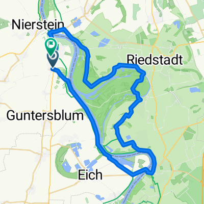
Route nach Eicher See-Eulenweg 1, Eich
A cycling route starting in Dienheim, Rhineland-Palatinate, Germany.
Overview
About this route
- 24 min
- Duration
- 9.8 km
- Distance
- 7 m
- Ascent
- 3 m
- Descent
- 24.4 km/h
- Avg. speed
- ---
- Avg. speed
Route quality
Waytypes & surfaces along the route
Waytypes
Track
9.2 km
(95 %)
Quiet road
0.5 km
(5 %)
Surfaces
Paved
7.8 km
(80 %)
Unpaved
1.5 km
(15 %)
Asphalt
7.8 km
(80 %)
Gravel
1.5 km
(15 %)
Continue with Bikemap
Use, edit, or download this cycling route
You would like to ride Route nach Eicher See-Eulenweg 1, Eich or customize it for your own trip? Here is what you can do with this Bikemap route:
Free features
- Save this route as favorite or in collections
- Copy & plan your own version of this route
- Sync your route with Garmin or Wahoo
Premium features
Free trial for 3 days, or one-time payment. More about Bikemap Premium.
- Navigate this route on iOS & Android
- Export a GPX / KML file of this route
- Create your custom printout (try it for free)
- Download this route for offline navigation
Discover more Premium features.
Get Bikemap PremiumFrom our community
Other popular routes starting in Dienheim
 47km Kühkopf-Tour
- Distance
- 47.5 km
- Ascent
- 56 m
- Descent
- 56 m
- Location
- Dienheim, Rhineland-Palatinate, Germany
 WRAG Rheinhessen Mix
- Distance
- 56.3 km
- Ascent
- 192 m
- Descent
- 115 m
- Location
- Dienheim, Rhineland-Palatinate, Germany
 Altrheintour
- Distance
- 45.7 km
- Ascent
- 61 m
- Descent
- 58 m
- Location
- Dienheim, Rhineland-Palatinate, Germany
 Sommertour 2009
- Distance
- 143.3 km
- Ascent
- 1,592 m
- Descent
- 1,214 m
- Location
- Dienheim, Rhineland-Palatinate, Germany
 Rhein-Hessen Tour #1
- Distance
- 44.4 km
- Ascent
- 220 m
- Descent
- 220 m
- Location
- Dienheim, Rhineland-Palatinate, Germany
 Oppenheim to Mainz
- Distance
- 20.5 km
- Ascent
- 62 m
- Descent
- 56 m
- Location
- Dienheim, Rhineland-Palatinate, Germany
 Taubhausring, Dienheim to Am Kuemmerling 18, Bodenheim
- Distance
- 13 km
- Ascent
- 132 m
- Descent
- 139 m
- Location
- Dienheim, Rhineland-Palatinate, Germany
 Unnamed Road, Oppenheim nach Blumenstraße 52, Heidelberg
- Distance
- 65.9 km
- Ascent
- 186 m
- Descent
- 169 m
- Location
- Dienheim, Rhineland-Palatinate, Germany
Open it in the app