

Masenbergrunde von Wenigzell
A cycling route starting in Sankt Jakob im Walde, Styria, Austria.
Overview
About this route
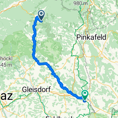
Radtour auf den Masenberg
Die Radtour startet am Dorfplatz in Wenigzell und führt über 40 km durch die Region bis auf den Masenberg. Die Rundtour ist als mittel eingestuft und führt über 1040 Höhenmeter. Die gut beschilderte Radtour ist von April bis Oktober befahrbar und perfekt für alle Radsportler.
- -:--
- Duration
- 40 km
- Distance
- 1,215 m
- Ascent
- 1,216 m
- Descent
- ---
- Avg. speed
- ---
- Avg. speed

Route quality
Waytypes & surfaces along the route
Waytypes
Quiet road
22.9 km
(57 %)
Track
15.6 km
(39 %)
Surfaces
Paved
12.9 km
(32 %)
Unpaved
13.1 km
(33 %)
Asphalt
12.9 km
(32 %)
Gravel
5.4 km
(14 %)
Continue with Bikemap
Use, edit, or download this cycling route
You would like to ride Masenbergrunde von Wenigzell or customize it for your own trip? Here is what you can do with this Bikemap route:
Free features
- Save this route as favorite or in collections
- Copy & plan your own version of this route
- Sync your route with Garmin or Wahoo
Premium features
Free trial for 3 days, or one-time payment. More about Bikemap Premium.
- Navigate this route on iOS & Android
- Export a GPX / KML file of this route
- Create your custom printout (try it for free)
- Download this route for offline navigation
Discover more Premium features.
Get Bikemap PremiumFrom our community
Other popular routes starting in Sankt Jakob im Walde
 Wildwiesenrunde
- Distance
- 24.1 km
- Ascent
- 587 m
- Descent
- 588 m
- Location
- Sankt Jakob im Walde, Styria, Austria
 Pittermann 78 nach Pittermann 78
- Distance
- 23.7 km
- Ascent
- 660 m
- Descent
- 660 m
- Location
- Sankt Jakob im Walde, Styria, Austria
 Familienhotel Berger
- Distance
- 19.9 km
- Ascent
- 533 m
- Descent
- 532 m
- Location
- Sankt Jakob im Walde, Styria, Austria
 Arzbergrunde von Wenigzell
- Distance
- 33.1 km
- Ascent
- 1,101 m
- Descent
- 1,098 m
- Location
- Sankt Jakob im Walde, Styria, Austria
 Bergstrecke in St. Jakob im Walde
- Distance
- 14.3 km
- Ascent
- 555 m
- Descent
- 554 m
- Location
- Sankt Jakob im Walde, Styria, Austria
 St. Jakob Pöllauberg CLONED FROM ROUTE 400253
- Distance
- 94.7 km
- Ascent
- 1,544 m
- Descent
- 1,557 m
- Location
- Sankt Jakob im Walde, Styria, Austria
 Arzbergrunde von Wenigzell
- Distance
- 4,138 km
- Ascent
- 14,486 m
- Descent
- 14,145 m
- Location
- Sankt Jakob im Walde, Styria, Austria
 Ratten - Fürstenfeld
- Distance
- 88.4 km
- Ascent
- 178 m
- Descent
- 882 m
- Location
- Sankt Jakob im Walde, Styria, Austria
Open it in the app