

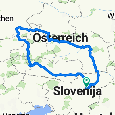
Hom - 2,0 km
A cycling route starting in Žalec, Občina Žalec, Slovenia.
Overview
About this route
- 4 h 14 min
- Duration
- 20.9 km
- Distance
- 460 m
- Ascent
- 458 m
- Descent
- 4.9 km/h
- Avg. speed
- ---
- Avg. speed
Route quality
Waytypes & surfaces along the route
Waytypes
Quiet road
9.1 km
(43 %)
Pedestrian area
4.7 km
(22 %)
Surfaces
Paved
4 km
(19 %)
Unpaved
3.2 km
(15 %)
Asphalt
4 km
(19 %)
Gravel
2.4 km
(11 %)
Continue with Bikemap
Use, edit, or download this cycling route
You would like to ride Hom - 2,0 km or customize it for your own trip? Here is what you can do with this Bikemap route:
Free features
- Save this route as favorite or in collections
- Copy & plan your own version of this route
- Sync your route with Garmin or Wahoo
Premium features
Free trial for 3 days, or one-time payment. More about Bikemap Premium.
- Navigate this route on iOS & Android
- Export a GPX / KML file of this route
- Create your custom printout (try it for free)
- Download this route for offline navigation
Discover more Premium features.
Get Bikemap PremiumFrom our community
Other popular routes starting in Žalec
 Zicer - Kraljevska 2022 (Žalec-Griže-Prebold-Dom pod Reško planino-Podmeja-Mrzlica-Žalec)
- Distance
- 49.9 km
- Ascent
- 1,346 m
- Descent
- 1,347 m
- Location
- Žalec, Občina Žalec, Slovenia
 TURA 2024 VIŠARJE
- Distance
- 478.3 km
- Ascent
- 8,471 m
- Descent
- 8,469 m
- Location
- Žalec, Občina Žalec, Slovenia
 Cesta na Lavo 11b to Gorica pri Šmartnem 16
- Distance
- 26.2 km
- Ascent
- 320 m
- Descent
- 311 m
- Location
- Žalec, Občina Žalec, Slovenia
 PO DOLENJSKEM
- Distance
- 361.3 km
- Ascent
- 2,296 m
- Descent
- 2,296 m
- Location
- Žalec, Občina Žalec, Slovenia
 BOSNA - MONTENEGRO
- Distance
- 1,246.2 km
- Ascent
- 5,442 m
- Descent
- 5,200 m
- Location
- Žalec, Občina Žalec, Slovenia
 HopsNaHom
- Distance
- 22.3 km
- Ascent
- 422 m
- Descent
- 419 m
- Location
- Žalec, Občina Žalec, Slovenia
 Kolesarjenje po Spodnji Savinjski dolini
- Distance
- 50.6 km
- Ascent
- 269 m
- Descent
- 269 m
- Location
- Žalec, Občina Žalec, Slovenia
 GrossGlockner Ciril
- Distance
- 952 km
- Ascent
- 3,159 m
- Descent
- 3,158 m
- Location
- Žalec, Občina Žalec, Slovenia
Open it in the app